 Filter: Categories of Wisconsin Historical Images
Filter: FORMAT_TYPE of prints, fine-art
Filter: Type of Map or Atlas
Filter: Categories of Wisconsin Historical Images
Filter: FORMAT_TYPE of prints, fine-art
Filter: Type of Map or Atlas

| Date: | 1866 |
|---|---|
| Description: | This map shows the location of county boundaries, cities, rivers, lakes, grant railroads, wagon roads, land office locations, iron, copper and lead deposit... |
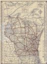
| Date: | 1923 |
|---|---|
| Description: | This map shows road surfacing, cities, rivers, towns, roads, highways, and camp sites. Included are portions of Minnesota, Iowa, Illinois, and Michigan. La... |
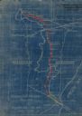
| Date: | 1949 |
|---|---|
| Description: | This map is comprised of six plates that depict the rout the Sauks and Meskwakis, led by Black Hawk, took through Wisconsin during the Black Hawk War of 18... |

| Date: | 08 1960 |
|---|---|
| Description: | This map shows a detailed account of southwestern Wisconsin. Individual settlers, the type of trees that grow in given areas, the quality of the soil (labe... |

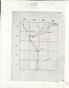
| Date: | 1900 |
|---|---|
| Description: | This map shows distances and land use along Dekorra and Sauk-Harbour road. It covers road between areas currently known as Dekorra and Port Washington, Wis... |

| Date: | 1900 |
|---|---|
| Description: | This map shows portion of the military road from Fond du Lac to the Wisconsin River near Fort Winnebago, with mile markers and adjacent land use. A few pro... |
| Date: | 1900 |
|---|---|
| Description: | This Plat map shows the second location of Helena's (of three) on the banks of the Wisconsin River. It also shows the location of shot tower northeast of t... |

| Date: | 1850 |
|---|---|
| Description: | This map shows the location of planned blocks and lot numbers, street names, and docks along the Fox River and canal. |
| Date: | 1923 |
|---|---|
| Description: | This blueprint map shows Wisconsin and Michigan-owned railroad and trackage rights from Iron Mountain to Menominee, Michigan, as well as other railroads. W... |
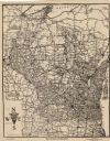
| Date: | 1924 |
|---|---|
| Description: | This map shows roads, cities, rivers,lakes, road surfacings and camp sites. Included are portions of Minnesota, Iowa, Illinois, and Michigan. Includes a le... |
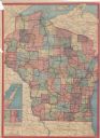
| Date: | 1933 |
|---|---|
| Description: | This map shows cities, rivers, lakes, roads, county boundaries, and destinations. Scenic and historic trails are shown in red. The map includes indexes to ... |
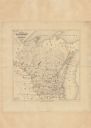
| Date: | 1865 |
|---|---|
| Description: | This map shows county boundaries and the congressional districts outlined and numbered in color. Included are portions of Minnesota, Iowa, Illinois and Mic... |
| Date: | 1913 |
|---|---|
| Description: | This map shows automobile roads, cities, county boundaries, rivers, lakes, railroads, electric lines, and congressional districts. Included are portions of... |
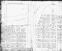
| Date: | 1900 |
|---|---|
| Description: | This map shows distances, land use, and landowners along the road from Racine to Janesville. The map is divided into several sheets with north typically or... |

| Date: | 1847 |
|---|---|
| Description: | This hand-colored map shows area north and west of Wisconsin River and south and east of Saint Louis and upper Mississippi Rivers. |

| Date: | 1846 |
|---|---|
| Description: | This map shows the plotting of the various townships in Wisconsin, both those that had been surveyed and some outlines for those which have not. A note in ... |

| Date: | 1916 |
|---|---|
| Description: | This map shows railroads, cities, rivers, lakes, and county boundaries. Select railroads are outlined in red. Portions of western Wisconsin Minnesota are v... |
| Date: | 1916 |
|---|---|
| Description: | The map on the front shows roads from Madison to northern Illinois and as far north as St. Croix, Chippewa, Marathon, and Shawano counties. The map on the ... |

| Date: | 1918 |
|---|---|
| Description: | This map shows counties, cities, towns, villages, summer resorts, lakes, rivers, creeks, wagon roads, roads, railroads, and electric lines. The authentic a... |
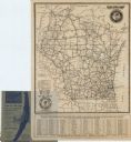
| Date: | 1920 |
|---|---|
| Description: | This map shows state trunk highways and other main highways. Lake Michigan is at the far right, with Lake Superior at the top. Included is a portion of Upp... |
If you didn't find the material you searched for, our Library Reference Staff can help.
Call our reference desk at 608-264-6535 or email us at: