Filter: Categories of Wisconsin Historical Images
Filter: FORMAT_TYPE of drawings
Filter: Subject of roads
Filter: Categories of Wisconsin Historical Images
Filter: FORMAT_TYPE of drawings
Filter: Subject of roads

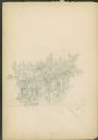
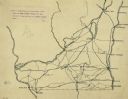
| Date: | 1936 |
|---|---|
| Description: | This map is red and black ink on tracing cloth and is oriented with north to the upper left. This hand-drawn map shows a central portion of the military ro... |
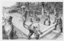
| Date: | 1948 |
|---|---|
| Description: | Pencil drawing of men building a corderoy road in the 1860's. Used for historical display for the Wisconsin State Highway Department. |

| Date: | 1832 |
|---|---|
| Description: | Hand-drawn map in two parts of the route of Governor J.D. Doty. Probably made by Doty in 1832 as a result of his travels with Alexander J. Center. |

| Date: | 1852 |
|---|---|
| Description: | Pencil drawing of Madison landscape as seen from University Hill. The main street in the center is State Street, and the building with Greek columns in the... |

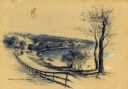
| Date: | 1852 |
|---|---|
| Description: | Pencil drawing of view overlooking Madison. The sketch looks down North Hamilton Street from the capitol. Rutted, irregular streets and frame houses mark ... |

| Date: | 1833 |
|---|---|
| Description: | Map of part of the military road from Fort Crawford to Fort Howard. "Recorded on pages 668.669 Book B." Surveyed by Lieut. Center. Scale: 2 miles = 1 inch. |
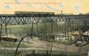
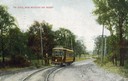
| Date: | 1911 |
|---|---|
| Description: | Elevated view across valley toward a streetcar viaduct on the Waukesha Interurban Line, near Milwaukee. Caption reads: "Street Car Bridge on Waukesha Inter... |
| Date: | 1911 |
|---|---|
| Description: | Colorized view of the railroad curve near Whitefish Bay resort. Caption reads: "The Curve near Whitefish Bay Resort." |

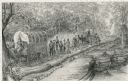
| Date: | 08 1852 |
|---|---|
| Description: | Pencil drawing of a dirt road through the woods with added white highlights. A horse-drawn wagon with two passengers moves down the road in the distance, ... |
| Date: | 09 01 1885 |
|---|---|
| Description: | Pencil on paper; Elevated view of building on street corner with horse-drawn delivery wagon in front. Tall trees line the two streets. Building is two st... |
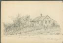
| Date: | 08 1885 |
|---|---|
| Description: | Pencil on paper; wood clapboard house behind fallen fence with open gate. Three trees, small outbuilding with one-sided roof, a large tub and other equipm... |

| Date: | |
|---|---|
| Description: | A hand-drawn map including the location of Daniel Boone's home and two forts, northeast of Lexington, Kentucky. |
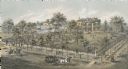
| Date: | 1872 |
|---|---|
| Description: | Lithograph elevated view of the Alexander Mitchell home and gardens seen from the corner of Ninth and Spring Streets. Pedestrians, horse-riders and a horse... |
| Date: | |
|---|---|
| Description: | A pencil drawing of men building a road with wooden planks. |
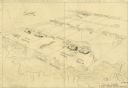
| Date: | 1922 |
|---|---|
| Description: | An ink on tracing paper, hand-drawn of south and eastern Wisconsin, illustrating the roads ranging from Dubuque, Iowa in the east to Green Bay, Wisconsin i... |

| Date: | 1863 |
|---|---|
| Description: | This map is a hand-colored, pen and ink, drawing by Ole R. Dahl of Co. B, 15 Wisconsin Infantry shows the battlefield at Stones River, depicting roads, str... |

| Date: | 1865 |
|---|---|
| Description: | This map is a pen and ink tracing. Union positions are shown in blue and Confederate positions are shown in red. Roads, vegetation, and streams are labeled... |

| Date: | 1860 |
|---|---|
| Description: | A hand-drawn, ink on cloth map of southeastern Wisconsin that show roads and railroads that connect Chicago to Milwaukee and other towns in the southeaster... |
If you didn't find the material you searched for, our Library Reference Staff can help.
Call our reference desk at 608-264-6535 or email us at: