 Filter: Categories of Wisconsin Historical Images
Filter: County of Sheboygan
Filter: Categories of Wisconsin Historical Images
Filter: County of Sheboygan

| Date: | 1865 |
|---|---|
| Description: | This map shows the harbor with proposed extensions and the shore line as it appeared in 1865. Depths are shown by soundings. |

| Date: | 1857 |
|---|---|
| Description: | This map shows piers, wharves, streets, and the lake shore from the survey of August 1856. Lake Michigan and the Sheboygan River are labeled. Depths are sh... |

| Date: | 1898 |
|---|---|
| Description: | View of a horse-drawn float decorated with banners and flags and rows of pharmaceuticals on shelves. Two costumed children are posing in the back. A large ... |

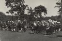
| Date: | 06 02 1930 |
|---|---|
| Description: | Governor Walter J. Kohler Sr. stands for a group portrait with several men and women on a lawn with trees and foliage. He is the fifth person from the righ... |
| Date: | 07 02 1930 |
|---|---|
| Description: | Governor Walter Kohler Sr. shakes the hand of a young boy, Henry Stoehr. They stand next to Henry Winsauer, and are surrounded by members of the Kohler Jun... |

| Date: | 07 02 1930 |
|---|---|
| Description: | Group portrait of four men standing outdoors under the wing of an airplane. From left to right: F.S. Brandenburg, Governor Kohler, George Charlesworth, and... |
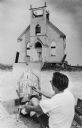
| Date: | 09 06 1968 |
|---|---|
| Description: | View of the front wall left standing of the Trinity Lutheran Church. A man in the foreground us painting a portrait of the church. The artist is identified... |

| Date: | 1926 |
|---|---|
| Description: | This blueprint map shows the Sheboygan River, buildings, and roads in the vicinity of the harbor. The map has explanations including "dredging required to ... |

| Date: | 1926 |
|---|---|
| Description: | This map includes a legend in the lower right corner of building heights. Districts marked "A" are 35 foot, districts marked "B" are 45 foot, districts mar... |

| Date: | 1926 |
|---|---|
| Description: | This map includes a legend in the lower right corner of land use. Districts are shown in five different shading for: "A" residential, "B" are residential, ... |

| Date: | 1940 |
|---|---|
| Description: | This map hows block and lot numbers, water mains, roads, parks, the Sheboygan River and some landownership. |
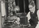
| Date: | 11 08 1932 |
|---|---|
| Description: | Charles E. Broughton delivering election returns over WHBL. |

| Date: | 1894 |
|---|---|
| Description: | This map shows railroads, street railways, ward lines, land parcels, streets, schools and public buildings. Ward lines are highlighted in red. Lake Michiga... |
| Date: | 1900 |
|---|---|
| Description: | This map shows the paper city situated at the mouth of the Memee (Pigeon) River in Sheboygan County, just north of Sheboygan. Land parcels, streets, and ri... |

| Date: | 2009 |
|---|---|
| Description: | Watercolor of a Native American burial site. Reconstructed stratigraphy and cross-section representative of effigy mounds at the Kletzien Mound group. |

| Date: | 2009 |
|---|---|
| Description: | Watercolor of a Native American burial site. Reconstructed stratigraphy and cross-section representative of effigy mounds at the Nitschke Mound group. |

| Date: | 1925 |
|---|---|
| Description: | This map shows trails, mounds, villages, corn fields, and contemporary civil townships; some villages and features include both Indian and English place na... |

| Date: | 1939 |
|---|---|
| Description: | This map originally dated March 18, 1920 and revised for this edition. The map shows the original meander line of 'Shebowegan Lake' established by 1850 sur... |

| Date: | |
|---|---|
| Description: | Because of the predominate Dutch background of people in the Cedar Grove area, it was decided by the Cedar Grove Booster Club to perpetuate this heritage w... |
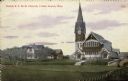
| Date: | 03 03 1910 |
|---|---|
| Description: | Hand-colored view of the Dutch R.F.M.D. Church. View across field or lawn. There is a dwelling and stable to the left of the church, and another building i... |
If you didn't find the material you searched for, our Library Reference Staff can help.
Call our reference desk at 608-264-6535 or email us at: