Filter: Categories of Wisconsin Historical Images
Filter: County of Sauk
Filter: Subject of intellectual life
Filter: Categories of Wisconsin Historical Images
Filter: County of Sauk
Filter: Subject of intellectual life
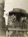
| Date: | 10 1900 |
|---|---|
| Description: | Robert M. La Follette, Sr., waving a flag from the back of a train as he campaigns for governor. |
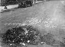
| Date: | 06 13 1918 |
|---|---|
| Description: | "Here lies the remains of German in B.H.S." is written on the pavement next to a smoldering pile of German textbooks. A car is parked along the curb in the... |

| Date: | 1965 |
|---|---|
| Description: | Office of author August Derleth, Wisconsin's Very Live Radio's (WVLR) unofficial consultant on the history of the Sauk-Prairie area. Derleth's novels and s... |

| Date: | 1870 |
|---|---|
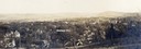
| Description: | Baraboo was first settled around 1838, and by 1870 it had become the county seat and the thriving village illustrated here. This birds eye drawing depicts ... |

| Date: | 1870 |
|---|---|
| Description: | Bird's-eye map of Prairie du Sac. |

| Date: | 1874 |
|---|---|
| Description: | Bird's-eye map of Reedsburg, on the Baraboo River. |

| Date: | 1870 |
|---|---|
| Description: | Sauk City is the oldest incorporated village in Wisconsin (incorporated in 1854) and also has the oldest organized volunteer fire department in the state, ... |
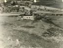
| Date: | 04 09 1931 |
|---|---|
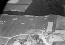
| Description: | Aerial view of Lake Delton airport. |

| Date: | 1883 |
|---|---|
| Description: | Bird's-eye map of Prairie du Sac, Wisconsin with an inset of Clifton. |

| Date: | 1883 |
|---|---|
| Description: | Bird's-eye map of Sauk City. |

| Date: | 1886 |
|---|---|
| Description: | Bird's-eye map of Baraboo with inset of Devil's Lake, the south and east sides of the commercial square, the First National Bank, and the Warren House hote... |

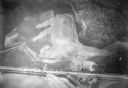
| Date: | 1955 |
|---|---|
| Description: | Aerial view of town, with the Baraboo River. |

| Date: | 1945 |
|---|---|
| Description: | Aerial view of the "powder storage area" of the Badger Ordnance Plant. |
| Date: | 1920 |
|---|---|
| Description: | Historic site marker to commemorate Man Mound and to mark Man Mound Park. The inscription reads "Man Mound Park. Mound located and platted by W.H. Canfield... |
| Date: | 1900 |
|---|---|
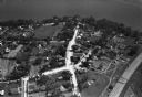
| Description: | Aerial view of town, with houses in foreground, and hills on the horizon in the background. Caption reads: "Baraboo, Wis." |
| Date: | |
|---|---|
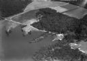
| Description: | Aerial view of the town, including the Wisconsin River, and the surrounding countryside. |
| Date: | 1930 |
|---|---|
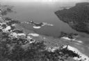
| Description: | Aerial view of Lake Delton, the Wisconsin River, and the surrounding countryside. |
| Date: | 1930 |
|---|---|
| Description: | Aerial view of Lake Delton and shoreline including resort areas. |
| Date: | 1930 |
|---|---|
| Description: | Aerial view of the Lake Delview Hotel, the golf course, and the surrounding countryside. |
If you didn't find the material you searched for, our Library Reference Staff can help.
Call our reference desk at 608-264-6535 or email us at: