 Filter: Categories of Wisconsin Historical Images
Filter: County of Price
Filter: Year of 1900-1999
Filter: Year of 1910-1919
Filter: Categories of Wisconsin Historical Images
Filter: County of Price
Filter: Year of 1900-1999
Filter: Year of 1910-1919
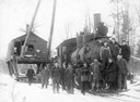
| Date: | 1914 |
|---|---|
| Description: | Taken on logging railroad, Lakeshore and Eastern Railroad, owned and operated by the Kneeland-McLurg Lumber company, Phillips, Wisconsin. Photograph is tak... |
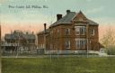
| Date: | 1910 |
|---|---|
| Description: | View across lawn towards the Price County Jail. Caption reads: "Price County Jail Phillips, Wis." |
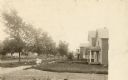
| Date: | 1910 |
|---|---|
| Description: | View across road towards a neighborhood along another road. Houses are on the right, and two children in the center are standing on the sidewalk in the cen... |
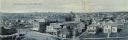
| Date: | 1910 |
|---|---|
| Description: | Elevated panoramic view of the town. Caption reads: "Bird's-Eye View of Park Falls, Wis." |

| Date: | 1910 |
|---|---|
| Description: | Park Hotel from a clipping taken from the Park Falls Herald of April 5, 1962. The caption reads: "Park Hotel was a landmark in the early days of Park Falls... |

| Date: | 1914 |
|---|---|
| Description: | This map of Price County, Wisconsin, from the early 20th century shows land for sale by the Homemaker Land Company of Milwaukee. The township and range sys... |

| Date: | 1910 |
|---|---|
| Description: | This map from the early 20th century shows the Wisconsin Central Railroad land grant lands owned and for sale by the Soo Line in Price County, Wisconsin, a... |

| Date: | 1914 |
|---|---|
| Description: | This 1914 map of Price County, Wisconsin, shows land for sale by the Good Land Company and Dewitt van Ostrand of Phillips. Also shown are the township and ... |

| Date: | 07 07 1915 |
|---|---|
| Description: | Ink on tracing cloth. Includes signed certifications from the surveyor, notary public, and Wisconsin Realty Company. From the E.P. Sherry papers relating t... |

| Date: | 1910 |
|---|---|
| Description: | This map is ink on paper. Shows Bruce’s proposed railway route and Moon’s railroad survey route along the Flambeau River, in parts of Lake and Eisenstein t... |
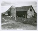
| Date: | 1917 |
|---|---|
| Description: | A log farm building and a silo, with a gaggle of geese in the barnyard. |
If you didn't find the material you searched for, our Library Reference Staff can help.
Call our reference desk at 608-264-6535 or email us at: