 Filter: Categories of Wisconsin Historical Images
Filter: County of Price
Filter: Subject of cities and towns
Filter: Year of 1900-1999
Filter: Categories of Wisconsin Historical Images
Filter: County of Price
Filter: Subject of cities and towns
Filter: Year of 1900-1999
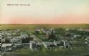
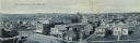
| Date: | 1905 |
|---|---|
| Description: | Elevated view of town. Caption reads: "Bird's-Eye View, Phillips, Wis." |
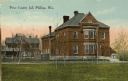
| Date: | 1910 |
|---|---|
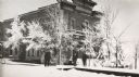
| Description: | View across lawn towards the Price County Jail. Caption reads: "Price County Jail Phillips, Wis." |
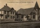
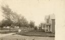
| Date: | 1900 |
|---|---|
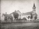
| Description: | View across road towards the church. Caption reads: "Congregational Church and Parsonage, Phillips, Wis." |
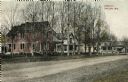
| Date: | 1905 |
|---|---|
| Description: | View looking across Avon Street. Caption reads: "Avon St., Phillips, Wis." |
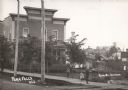
| Date: | 1910 |
|---|---|
| Description: | View across road towards a neighborhood along another road. Houses are on the right, and two children in the center are standing on the sidewalk in the cen... |
| Date: | 1910 |
|---|---|
| Description: | Elevated panoramic view of the town. Caption reads: "Bird's-Eye View of Park Falls, Wis." |
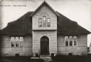
| Date: | 1900 |
|---|---|
| Description: | View of the front of the public school established in 1896. Caption reads: "Public School, Park Falls, Wis." |
| Date: | 1900 |
|---|---|
| Description: | View across road towards the Park Hotel, with children playing on the sidewalk in front of the hotel. Caption reads: "Park Falls, Wis." |

| Date: | 1900 |
|---|---|
| Description: | Front view of the Park Hotel, with an obstructed view, through trees, of the porch. |

| Date: | 1910 |
|---|---|
| Description: | Park Hotel from a clipping taken from the Park Falls Herald of April 5, 1962. The caption reads: "Park Hotel was a landmark in the early days of Park Falls... |
| Date: | 1900 |
|---|---|
| Description: | A view of the Park Hotel in winter. A man on the left is pulling a sled piled with firewood. |

| Date: | 1905 |
|---|---|
| Description: | Exterior view of the high school. Caption reads: "High School, Park Falls, Wis." |
| Date: | 04 25 1931 |
|---|---|
| Description: | A view of a church and what appears to be the adjoining rectory. This is the Parish of St. Anthony in the town of Fifield. |

| Date: | 1914 |
|---|---|
| Description: | This map of Price County, Wisconsin, from the early 20th century shows land for sale by the Homemaker Land Company of Milwaukee. The township and range sys... |

| Date: | 1925 |
|---|---|
| Description: | This map of Price County, Wisconsin, from the early 20th century shows the township and range system, towns, sections, cities and villages, railroads, high... |

| Date: | 1910 |
|---|---|
| Description: | This map from the early 20th century shows the Wisconsin Central Railroad land grant lands owned and for sale by the Soo Line in Price County, Wisconsin, a... |

| Date: | 1914 |
|---|---|
| Description: | This 1914 map of Price County, Wisconsin, shows land for sale by the Good Land Company and Dewitt van Ostrand of Phillips. Also shown are the township and ... |

| Date: | 1925 |
|---|---|
| Description: | This map of Price County, Wisconsin, from the early 20th century shows the township and range system, towns, sections, cities and villages, railroads, high... |

| Date: | 1910 |
|---|---|
| Description: | This map is ink on paper. Shows Bruce’s proposed railway route and Moon’s railroad survey route along the Flambeau River, in parts of Lake and Eisenstein t... |

| Date: | 07 05 1994 |
|---|---|
| Description: | As a boy scout raises the flag, the people in attendance at the Park Falls Fourth of July celebration recite the Pledge of Allegiance. Congressman David R.... |
If you didn't find the material you searched for, our Library Reference Staff can help.
Call our reference desk at 608-264-6535 or email us at: