Filter: Categories of Wisconsin Historical Images
Filter: County of Ozaukee
Filter: Year of 1900-1999
Filter: Year of 1950-1959
Filter: Categories of Wisconsin Historical Images
Filter: County of Ozaukee
Filter: Year of 1900-1999
Filter: Year of 1950-1959
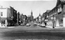
| Date: | 1950 |
|---|---|
| Description: | View of the central business area on Franklin Street. On the right corner is the "Fish Shanty" Restaurant and on the left is the Rexall Drugstore. |
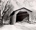
| Date: | 1957 |
|---|---|
| Description: | Covered bridge over Cedar Creek in Ozaukee County on highway, about one mile north of Cedarburg. The last remaining covered bridge in Wisconsin. Snow is on... |
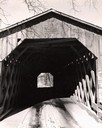
| Date: | 1957 |
|---|---|
| Description: | View through the covered bridge over Cedar Creek in Ozaukee County on highway, about one mile north of Cedarburg. The last remaining covered bridge in Wisc... |
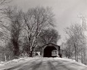
| Date: | 1957 |
|---|---|
| Description: | Covered bridge over Cedar Creek in Ozaukee County on highway, about one mile north of Cedarburg. The last remaining covered bridge in Wisconsin. Snow is on... |
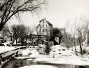
| Date: | 1950 |
|---|---|
| Description: | The Thiensville Mill as seen from the waterfront. |
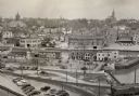
| Date: | 1952 |
|---|---|
| Description: | An elevated view of the downtown section. |
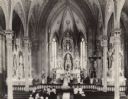
| Date: | 1952 |
|---|---|
| Description: | Elevated view towards the altar at St. Mary's Church on the occasion of Donald Schleuter's wedding. |
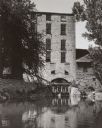
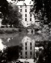
| Date: | 1956 |
|---|---|
| Description: | View across water of the Old Mill surrounded by trees and water. Water is coming out of an opening in an archway of the mill. On the left automobiles are p... |

| Date: | 01 09 1958 |
|---|---|
| Description: | Elevated view from bluff of the harbor towards the southeast. At the end of a jetty is a lighthouse on the left. The water is frozen along the shoreline. T... |

| Date: | 01 09 1958 |
|---|---|
| Description: | View of Port Washington Harbor from Wisconsin Electric Power Company wharf. The city is in the background along the shoreline. |
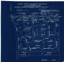
| Date: | 04 1958 |
|---|---|
| Description: | This blueprint map shows additions, sections, and streets. The upper left of the map reads: "Plan for 6ʺ watermain, hydrants & appurtenances." The up... |
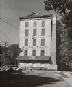
| Date: | 1956 |
|---|---|
| Description: | View down road towards two people walking in front of the Thienville Mills, a five-story stone building, built in 1876. At this time, it was the Thiensvill... |
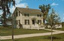
| Date: | 1957 |
|---|---|
| Description: | A timber and masonry house in the Ozaukee County Pioneer Village. Text on back reads: "Ozaukee County, Pioneer Village, Wisconsin. Karl Zettler Half-Timber... |
| Date: | 1957 |
|---|---|
| Description: | A log house in the Ozaukee County Pioneer Village. Text on back reads: "Ozaukee County, Pioneer Village, Wisconsin. Typical of the home built by German Imm... |
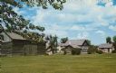
| Date: | 1957 |
|---|---|
| Description: | A Pioneer Village with timber and masonry structures. Text on back reads: "Ozaukee County, Pioneer Village, Wisconsin. Authentic Buildings and Furnishings.... |
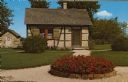
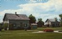
| Date: | 1957 |
|---|---|
| Description: | A clapboard house with a white picket fence in the Ozaukee County Pioneer Village. Text on back reads: "Ozaukee County, Pioneer Village, Wisconsin. Halpin ... |
If you didn't find the material you searched for, our Library Reference Staff can help.
Call our reference desk at 608-264-6535 or email us at: