Filter: Categories of Wisconsin Historical Images
Filter: County of Milwaukee
Filter: Year of 1800-1899
Filter: Subject of transportation
Filter: Year of 1860-1869
Filter: Categories of Wisconsin Historical Images
Filter: County of Milwaukee
Filter: Year of 1800-1899
Filter: Subject of transportation
Filter: Year of 1860-1869

| Date: | 1862 |
|---|---|
| Description: | Drawn the second year of the Civil War, this 1862 map of Milwaukee shows post offices, light houses, beacon lights, county buildings, elevator warehouses, ... |
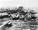
| Date: | 1865 |
|---|---|
| Description: | Elevated view of the first Milwaukee railroad depot, which was used by the Milwaukee & Waukesha and the Milwaukee & Mississippi railroads. The Milwaukee &... |
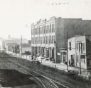
| Date: | 1869 |
|---|---|
| Description: | Stereograph of the Axtell House building, with a storefront next to it advertising "Clothing Hats Caps Sailors Outfits". A bridge is on the left and a man... |
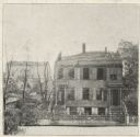
| Date: | 1865 |
|---|---|
| Description: | After the fire of Oct. 22, 1865. The house takes up most of the image to the right, with burnt trees on the left, and a building in the background. The r... |

| Date: | 1866 |
|---|---|
| Description: | Stereograph. This building, which was destroyed by fire in 1866, was located in the commercial district known as Market Square. The Square was actually a t... |
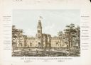
| Date: | 1867 |
|---|---|
| Description: | E.T. Mix designed the original building of the National Soldiers Home in 1867. At the time the structure was dedicated on 28 September 1867, the wings had ... |

| Date: | 1860 |
|---|---|
| Description: | Image drawn by Franz Hölzlhuber of early Milwaukee settlement with a horse-drawn carriage, as well as industry and a railroad. The text on the image reads:... |

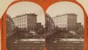
| Date: | 1868 |
|---|---|
| Description: | Elevated view over rooftops looking towards Lake Michigan shoreline. Seaman's Furniture and Rooms building is surrounded by other commercial buildings. The... |
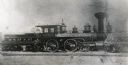
| Date: | 1869 |
|---|---|
| Description: | Milwaukee and St. Paul Railway locomotive no. 40, called the L.B. Rock, at the Chestnut Street yards. The mast of a ship is visible in the background, and ... |

| Date: | 1866 |
|---|---|
| Description: | Stereograph. This building, which was destroyed by fire in 1866, was located in the commercial district known as Market Square. The Square was actually a t... |
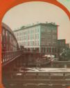
| Date: | 1869 |
|---|---|
| Description: | Stereograph of the Axtell House building, with a storefront next to it advertising "Clothing Hats Caps Sailors Outfits". A bridge is on the left and a man... |

| Date: | 1861 |
|---|---|
| Description: | Map with labelled block and lot numbers, owners of large property parcels, city wards, railroads, and streets. Population from 1835 to 1860 listed below ti... |

| Date: | 1863 |
|---|---|
| Description: | Includes index to public buildings, churches, schools. Inset: Glidden & Lockwood’s addition. Gives names of some property owners. |

| Date: | 1869 |
|---|---|
| Description: | This map was engraved from original drawings and surveys taken by Louis Lipman. Includes Milwaukee street directory on the left hand side. Bottom right cor... |

| Date: | 1869 |
|---|---|
| Description: | Map shows townships and sections, landownership and acreages, buildings, and marshes. The map includes insets of Franklin, Hales Corners, Bay View, Oak Cre... |

| Date: | 1860 |
|---|---|
| Description: | Map shows meadows, forests, buildings, railroad, and lots south of part of the city of Milwaukee. Relief shown by hachures. Includes list of lot acreages. |

| Date: | 1868 |
|---|---|
| Description: | This map shows lot and block numbers, some property ownership, wards, roads, and railroads. An inset map shows the Glidden & Lockwood’s addition. There are... |

| Date: | 1869 |
|---|---|
| Description: | This map shows lot and block numbers, some property ownership, wards, roads, and railroads and includes inset map of Glidden & Lockwood’s addition. There a... |
If you didn't find the material you searched for, our Library Reference Staff can help.
Call our reference desk at 608-264-6535 or email us at: