 Filter: Categories of Wisconsin Historical Images
Filter: County of Milwaukee
Filter: Year of 1800-1899
Filter: Creator Name of Unknown
Filter: Categories of Wisconsin Historical Images
Filter: County of Milwaukee
Filter: Year of 1800-1899
Filter: Creator Name of Unknown

| Date: | 1830 |
|---|---|
| Description: | A hand-drawn map of the township sectioning of Milwaukee, eastern Waukesha, northern Walworth, and Racine Counties. Other items shown in the map are the la... |

| Date: | 1896 |
|---|---|
| Description: | A map of Milwaukee County, Wisconsin that shows the township and range system, sections, towns, roads, railroads and rail stations, cities and villages, po... |
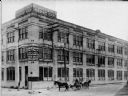
| Date: | 1899 |
|---|---|
| Description: | Exterior view of the building at the corner of N. 12th St. and W. St. Paul Avenue that housed Badger State Shoe Co. and Saveland Manufacturing Co. Two hors... |
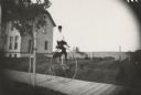
| Date: | 1890 |
|---|---|
| Description: | Young man riding a High Wheel or Penny-Farthing bicycle on a wooden sidewalk. There is a house behind the rider on the left. A young tree braced with a sta... |

| Date: | 1835 |
|---|---|
| Description: | This map is pen-and-ink on paper. The map shows landowners in "Milwalky" or present day Milwaukee. Includes "list of property offered to Mr. Walker". The m... |

| Date: | 1836 |
|---|---|
| Description: | This map shows settlers houses and businesses, trails, and swamps. The relief is shown by hachures. The map includes illustrations of historical buildings ... |

| Date: | 1890 |
|---|---|
| Description: | Map of Milwaukee as remembered by "Dr Enoch Chase, U.B. Smith & Others." Represented are major roads, lowlands, trails, homesteads, and lots. Map depicts t... |

| Date: | 06 1837 |
|---|---|
| Description: | Pen-and-ink on paper. Shows riverside property west of the Milwaukee River. Inscribed by several early Milwaukee settlers, including Henry W. Cleveland, Cy... |

| Date: | 1857 |
|---|---|
| Description: | Caption reads: "THE LOTS embraced in the proposed Addition, are situated in the Fourth Ward of the City of Milwaukee, about twenty minutes walk from Spring... |

| Date: | 1858 |
|---|---|
| Description: | Map of Martineau's Addition in the first ward of Milwaukee as well as buildings and location of adjacent additions with landowners names. |

| Date: | 1836 |
|---|---|
| Description: | This map is pen-and-ink on paper and shows marshlands, rivers, creeks, a quarry, and a few roads. |

| Date: | 1840 |
|---|---|
| Description: | Pen-and-ink on paper. Map shows 1840’s homes with owner names, a Native American cemetery, and other points of interest. Relief shown by hachures. Oriented... |

| Date: | 1800 |
|---|---|
| Description: | Ink on tracing cloth. Shows property owners in block 69, between Fourth and Third Street. |

| Date: | 1800 |
|---|---|
| Description: | Map of additions to Milwaukee. Several of the additions are outlined in colors and many streets, waterways, and some landmarks are labelled. |
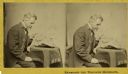
| Date: | 1868 |
|---|---|
| Description: | Stereograph of Increase Lapham examining a fragment of a meteorite. |
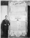
| Date: | 1893 |
|---|---|
| Description: | John Fawcett Tyrrell, handwriting expert and documents examiner of Milwaukee, standing at left of an illuminated poster, ten feet high, entitled "The Histo... |

| Date: | 1800 |
|---|---|
| Description: | An ink on paper map for a plan of mounds in Milwaukee county. The map is situated pointing north. |

| Date: | 1860 |
|---|---|
| Description: | Map shows meadows, forests, buildings, railroad, and lots south of part of the city of Milwaukee. Relief shown by hachures. Includes list of lot acreages. |
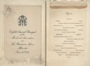
| Date: | 06 23 1885 |
|---|---|
| Description: | Menu card and satin overlay with the intertwined initials "M" and "A" for the Eighth Annual Banquet of the Merchants Association at Plankinton House. The f... |
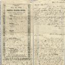
| Date: | 09 21 1846 |
|---|---|
| Description: | Bill of fare for the United States Hotel, with decorative border ornaments running along the sides, top, and bottom of the menu, and general printed catego... |
If you didn't find the material you searched for, our Library Reference Staff can help.
Call our reference desk at 608-264-6535 or email us at: