 Filter: Categories of Wisconsin Historical Images
Filter: County of Manitowoc
Filter: Year of 1800-1899
Filter: Categories of Wisconsin Historical Images
Filter: County of Manitowoc
Filter: Year of 1800-1899

| Date: | 1874 |
|---|---|
| Description: | This map shows piers, streets, the Manitowoc River and shore lines of 1856, 1869, 1873 and 1874. The top margin reads; "Soundings taken 1974." Written in i... |

| Date: | 1875 |
|---|---|
| Description: | Team of oxen pulling a wagon in front of Schuette Brothers store grain warehouse on a muddy Jay Street. The man standing with the oxen is likely Fred Wilke... |

| Date: | 1870 |
|---|---|
| Description: | This blueprint map shows lot and block numbers, streets, and right of way for the Two Rivers Branch railroad. The map covers land west to sections 22 and 2... |

| Date: | 1891 |
|---|---|
| Description: | View down tree-lined sidewalk along Marshall Street facing west. The northwest corner of S. 6th and Marshall Streets is circled by a fence, which continue... |

| Date: | 1899 |
|---|---|
| Description: | View across Franklin Street of the Manitowoc Aluminum Novelty Company on the southwest corner of S. 15th and Franklin Streets. This very first picture of t... |
| Date: | 1898 |
|---|---|
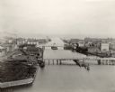
| Description: | Bird's-eye view of the Manitowoc Harbor facing east from Northern Grain Company's Elevator B. In the foreground, Mathews & Keith's pile driver scow is secu... |
| Date: | 1898 |
|---|---|
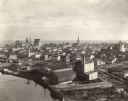
| Description: | Bird's-eye view of Manitowoc taken from Northern Grain Company's Elevator B, facing southeast. South Main (Tenth) Street intersects with Franklin Street in... |
If you didn't find the material you searched for, our Library Reference Staff can help.
Call our reference desk at 608-264-6535 or email us at: