 Filter: Categories of Wisconsin Historical Images
Filter: County of Manitowoc
Filter: Creator Name of Unknown
Filter: Categories of Wisconsin Historical Images
Filter: County of Manitowoc
Filter: Creator Name of Unknown

| Date: | 01 08 1958 |
|---|---|
| Description: | View of Two Rivers Harbor from shoreline towards Lake Michigan. Snow is on the ground, and a fence made of thick posts and cable is along the shoreline on ... |

| Date: | 1856 |
|---|---|
| Description: | This map shows the Manitowoc River, Lake Michigan, streets, and buildings. Relief is shown by hachures and soundings are in feet and decimals of a foot. Th... |

| Date: | 09 1853 |
|---|---|
| Description: | This map shows streets, docks, warehouses, and piers near the harbor. The Manitowoc River and Lake Michigan are labeled. Depths are indicated by soundings ... |

| Date: | 1856 |
|---|---|
| Description: | This map shows streets, piers, and wharves. Lake Michigan, the Manitowoc River, and select buildings are labeled. Relief is shown by hachures and sounding... |

| Date: | 1865 |
|---|---|
| Description: | This map shows the river shore and piers. Lake Michigan is labeled. Depths are shown by soundings and isolines. The bottom margin includes notes on soundi... |

| Date: | 1874 |
|---|---|
| Description: | This map shows piers, streets, the Manitowoc River and shore lines of 1856, 1869, 1873 and 1874. The top margin reads; "Soundings taken 1974." Written in i... |

| Date: | 1903 |
|---|---|
| Description: | This map shows lakes, roads, railroads, townships, and land ownership by name. Counties are colored red, blue, or yellow. Lake Michigan is labeled. Also in... |
| Date: | 09 09 1954 |
|---|---|
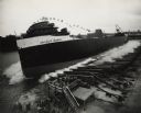
| Description: | Elevated view of the sideways launching of Hull 418, the Detroit Edison at Manitowoc Shipbuilding, Inc. A group of people are gathered at the wharf ... |
| Date: | |
|---|---|
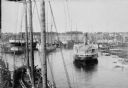
| Description: | Elevated view of commercial boats in Manitowoc Harbor. |

| Date: | 1870 |
|---|---|
| Description: | This blueprint map shows lot and block numbers, streets, and right of way for the Two Rivers Branch railroad. The map covers land west to sections 22 and 2... |

| Date: | 1951 |
|---|---|
| Description: | This map shows city streets, zoning of city areas, residences, local businesses, and commercial areas marked in red, yellow, and light brown. The bottom ri... |

| Date: | 1903 |
|---|---|
| Description: | Elevated view from across the street of the new North Side Fire Station, Fire Station No. 1, at 412 N. 8th Street. The construction is two-story brick, ha... |
| Date: | 1906 |
|---|---|
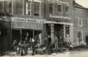
| Description: | Albert Worel, Frank Zeman and Jacob Stangel are standing in front of the brick and wood-frame buildings of their York St. hardware store. The company's del... |
| Date: | |
|---|---|
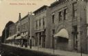
| Description: | Photographic postcard view of a city block lined with businesses on the right. The State Bank is in the foreground on the right, and a restaurant is next d... |
| Date: | 08 1916 |
|---|---|
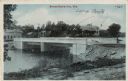
| Description: | View of a bridge over the Sheboygan River. There are lampposts on each corner of the bridge, indicated by arrows. Caption reads: "Bridge Scene, Kiel, Wis." |
| Date: | 1910 |
|---|---|
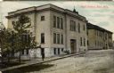
| Description: | Colorized postcard view across street towards the brick high school on the left. A group of students are on the sidewalk outside of the entrance, and a man... |

| Date: | 1910 |
|---|---|
| Description: | Quarter-length studio portrait of Arthur J. Packard, an early Manitowoc photographer known for views of the area, its people, harbor and marine vessels fro... |

| Date: | 1891 |
|---|---|
| Description: | View down tree-lined sidewalk along Marshall Street facing west. The northwest corner of S. 6th and Marshall Streets is circled by a fence, which continue... |

| Date: | 1908 |
|---|---|
| Description: | Birds-eye view of central Manitowoc. The plant of the William Rahr Sons' Company has an arrow pointing to it. The Manitowoc County Courthouse on the right ... |

| Date: | |
|---|---|
| Description: | View of a motel on U.S. Hwy. 141 2 miles southwest of Manitowoc. The front has a AAA logo. There is a map showing the location on the reverse. Caption read... |
If you didn't find the material you searched for, our Library Reference Staff can help.
Call our reference desk at 608-264-6535 or email us at: