 Filter: Categories of Wisconsin Historical Images
Filter: County of Ashland
Filter: Subject of farms
Filter: Categories of Wisconsin Historical Images
Filter: County of Ashland
Filter: Subject of farms

| Date: | 1913 |
|---|---|
| Description: | Elizabeth Baker and Anne Ashley waiting for milk at Grant's Point Farm, Madeline Island. The dog is "Dandy," born in Munich, Germany. |

| Date: | 1895 |
|---|---|
| Description: | A man stands in a field in Ashland County, almost dwarfed by grain plants. |

| Date: | 1910 |
|---|---|
| Description: | Three young men and a girl standing at South Shore Farm located on an Apostle Island. |
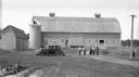
| Date: | 1938 |
|---|---|
| Description: | Group of men and a child standing near a barn and silo. A car is parked nearby. |
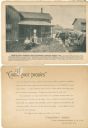
| Date: | 09 05 1895 |
|---|---|
| Description: | A promotional card advertising the prosperous life of Chas Kohlman, a Northern Wisconsin farmer. The image at the center of the card shows the Kohlman fami... |

| Date: | 1890 |
|---|---|
| Description: | This map shows the Wisconsin Central Railroad land grant lands owned and for sale by the Soo Line in Ashland County, Wisconsin, as well as in portions of B... |

| Date: | 1890 |
|---|---|
| Description: | This 1890s map shows the Wisconsin Central Railroad land grant lands owned and for sale by the Soo Line in Ashland County, Wisconsin, as well as in the eas... |

| Date: | 1908 |
|---|---|
| Description: | Title at top: "G.F. Sanborn Company Timber and Farming Lands." Map shows acreages, roads, railroads, and swamps in parts of Vilas and Oneida counties. |

| Date: | 1947 |
|---|---|
| Description: | This map of Ashland is a cadastral map showing some rural landowners and includes index to points of interest. The map shows roads, railroads, parks, cemet... |

| Date: | 1915 |
|---|---|
| Description: | This map shows school houses, churches, farms, and railroads. Chequamecon Bay and Bad River Indian Reservation are labeld. The map reads: "All lands shown ... |
If you didn't find the material you searched for, our Library Reference Staff can help.
Call our reference desk at 608-264-6535 or email us at: