Filter: Categories of Wisconsin Historical Images
Filter: Community of Plymouth
Filter: Subject of transportation
Filter: Subject of human settlements
Filter: Categories of Wisconsin Historical Images
Filter: Community of Plymouth
Filter: Subject of transportation
Filter: Subject of human settlements
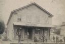
| Date: | 1888 |
|---|---|
| Description: | Exterior view of Charles Pfeifer's Drugstore, founded in 1858. From left to right are Charles Pfeifer, Fred Pfeifer, Mrs. Adam Heeb, Fulda Pfeifer, Mrs. Ch... |
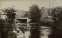
| Date: | 1910 |
|---|---|
| Description: | View of the Mullet River, with an bridge and an industrial building in the background. A sign reads, in part: "MFG. CO." |
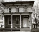
| Date: | 1963 |
|---|---|
| Description: | A house with a porch. An example of mid-nineteenth century architecture at 632 East Main Street. |
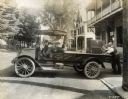
| Date: | 1917 |
|---|---|
| Description: | Three men loading a piece of furniture onto the bed of an International Model F (or 31) truck. The truck was operated by the A.F. Burtt Company. On the tru... |

| Date: | 03 25 1952 |
|---|---|
| Description: | Presidential candidate Harold E. Stassen, standing by his campaign bus, beseiged by young autograph collectors. On January 29, Stassen, a former governor o... |

| Date: | 1915 |
|---|---|
| Description: | View of main street from a city park, including parked cars and store fronts. |
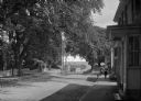
| Date: | |
|---|---|
| Description: | View of Plymouth Street looking towards the waterfront with large trees along the sidewalks. |

| Date: | 1910 |
|---|---|
| Description: | Pemigewasset National Bank was among the members of the Federal Reserve. In this view, an automobile is on the left, and three men stand at the bank's entr... |

| Date: | |
|---|---|
| Description: | View of a wooden structure, with wood planks and wheels on the lawn outside. The sign above the door reads: "H. Farnum, Wheelwright." Caption reads: "Old C... |

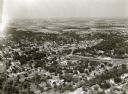
| Date: | |
|---|---|
| Description: | Aerial view of Plymouth. Published by McLaughlin Aerial Surveys. |

| Date: | |
|---|---|
| Description: | Exterior of Pilgrim Hall in a town setting. A horse and carriage waits outside the museum with a colonnaded porch. |

| Date: | |
|---|---|
| Description: | Exterior view of Howland House, a colonial dwelling. Text on the sign outside the house reads, "Oldest House in Plymouth, Built 1667-Restored 1913, The la... |

| Date: | |
|---|---|
| Description: | View down a narrow town street with closely spaced homes. |

| Date: | 1959 |
|---|---|
| Description: | This map shows some land ownership, lot and block numbers, additions, fair grounds, streets, and railroads and is indexed. Mullet River and Mill Pond are l... |

| Date: | 1940 |
|---|---|
| Description: | A young boy wearing knickers, high stockings and a jacket is watching two swans on the Mullet River. A bridge and the rear of commercial buildings are in t... |
If you didn't find the material you searched for, our Library Reference Staff can help.
Call our reference desk at 608-264-6535 or email us at: