 Filter: Categories of Wisconsin Historical Images
Filter: Community of Hurley
Filter: Subject of human settlements
Filter: Subject of transportation
Filter: Categories of Wisconsin Historical Images
Filter: Community of Hurley
Filter: Subject of human settlements
Filter: Subject of transportation

| Date: | 1886 |
|---|---|
| Description: | Bird's-eye map of Hurley with insets Mining at the Colby, Hurley in 1885, and North Front of Silver Street. |
| Date: | 1885 |
|---|---|
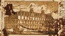
| Description: | Burton House, (also referred to as the Ridge House by Edna Ferber in her novel, "Come and Get It") with horse-drawn carriages in the foreground. |
| Date: | 1905 |
|---|---|
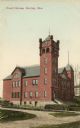
| Description: | View across road toward the court house. Caption reads: "Court House, Hurley, Wis." |

| Date: | 1942 |
|---|---|
| Description: | View up Silver Street in Hurley. |
| Date: | 08 02 1942 |
|---|---|
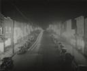
| Description: | Elevated view of Silver Street in Hurley at 4:30 a.m., Sunday morning, showing busy street and all establishment's lights blazing. After the sweeping raid ... |
| Date: | 1908 |
|---|---|
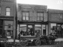
| Description: | View from street of man seated on a horse-drawn wagon on Silver Street, which is parked in front of (from left to right) Joseph Rainieri Meat Market, Egan ... |
| Date: | 1935 |
|---|---|
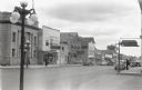
| Description: | View of Main Street from sidewalk. Across the street are buildings with signs that read from left to right "First National Bank," "Johns Hardware Paints St... |

| Date: | 09 1891 |
|---|---|
| Description: | Sanborn map of Hurley, featuring the Village of Gile and the Montreal River Lumber Company. |

| Date: | 1898 |
|---|---|
| Description: | Sanborn map of Hurley featuring the Village of Gile. |

| Date: | 02 1898 |
|---|---|
| Description: | Sanborn map of Hurley featuring the Montreal Mining Company. |

| Date: | 11 1905 |
|---|---|
| Description: | Sanborn map of Hurley including mining features. |

| Date: | 1903 |
|---|---|
| Description: | View towards vehicles in the street, including hearses, and horses from the Burton House Livery parked along the curb in front of storefronts. Men stand ho... |

| Date: | 1930 |
|---|---|
| Description: | This map shows schools, school districts, town sections, highways, railroads, and hydrography of the area around Hurley. The right margin includes and expl... |
| Date: | |
|---|---|
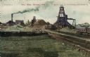
| Description: | View of the Cary iron Mine. Railroad tracks are in the right foreground. Caption reads: "Cary Mine, Hurley, Wis." |
| Date: | 1959 |
|---|---|
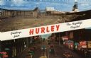
| Description: | Two views of Hurley. At the top is the Cary Mine. On the bottom is Silver Street lined with clubs and electric signs. Caption reads: "Greetings from Hurley... |
| Date: | |
|---|---|
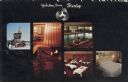
| Description: | Five views from the Holiday Inn. Includes the Holiday Inn sign, interior view of the lobby, pool, restaurant and a guest room. Caption reads: "Holiday Inn,... |

| Date: | |
|---|---|
| Description: | Stereograph of an elevated view of a parade marching through town. Many of the participants are wearing uniforms, and some are carrying musical instruments... |

| Date: | 1907 |
|---|---|
| Description: | Elevated view of Hurley, WI and nearby industrial sites (Scott & Howe Lumber Co. Mill, Ashland Mine). Inventory reads: "Looking west and a little south ove... |

| Date: | 1905 |
|---|---|
| Description: | Slightly elevated view of the border between Hurley, WI and Ironwood, MI. Caption reads: "Looking east from Hurley side of Montreal River near Silver Stree... |

| Date: | 1887 |
|---|---|
| Description: | A view of the businesses present on Silver Street, Hurley's main street, less than three years after the city's settlement. City residents and a horse-dra... |
If you didn't find the material you searched for, our Library Reference Staff can help.
Call our reference desk at 608-264-6535 or email us at: