 Filter: Categories of Wisconsin Historical Images
Filter: Creator Name of Wisconsin. Conservation Department.
Filter: Year of 1900-1999
Filter: Year of 1930-1939
Filter: Categories of Wisconsin Historical Images
Filter: Creator Name of Wisconsin. Conservation Department.
Filter: Year of 1900-1999
Filter: Year of 1930-1939
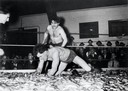
| Date: | 04 1939 |
|---|---|
| Description: | Two men smelt wrestling at the Smelt Carnival in Marinette. |
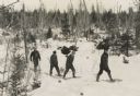
| Date: | 1935 |
|---|---|
| Description: | Winter scene with four men walking on snowshoes through a forest. |
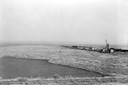
| Date: | 1936 |
|---|---|
| Description: | Elevated view of logs tugged across Lake Superior to the harbor at Ashland. |
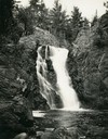
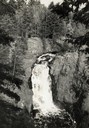
| Date: | 1935 |
|---|---|
| Description: | View from rocky shoreline towards the Brownstone Falls in Copper Falls State Park. |
| Date: | 1935 |
|---|---|
| Description: | Elevated view of the Brownstone Falls on the Bad River. |
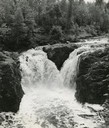
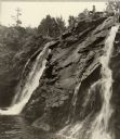
| Date: | 1937 |
|---|---|
| Description: | Elevated view of the waterfall where the Bad River tumbles over the Keweenawan Trap Ledge. |
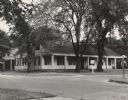
| Date: | 1935 |
|---|---|
| Description: | Fort Howard hospital sheltered by large trees. |
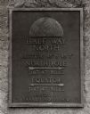
| Date: | 1938 |
|---|---|
| Description: | The 45th parallel of north latitude marker, marking halfway between the equator and the north pole. The marker is located on Highway 141, three miles north... |
| Date: | 1936 |
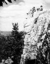
|---|---|
| Description: | A rock outcropping with children at Rib Mountain State Park. |

| Date: | 1930 |
|---|---|
| Description: | A view looking west at Rib Mountain across the Wisconsin River from the outskirts of Wausau. |
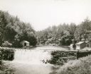
| Date: | 1930 |
|---|---|
| Description: | View of the mill dam on Dell Creek that creates Mirror Lake in Mirror Lake State Park (although the photograph was taken before the site was designated as ... |
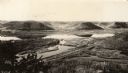
| Date: | 1930 |
|---|---|
| Description: | Elevated view of Perrot State Park (Trempealeau vicinity) looking west from Brady's Bluff toward the Mississippi River and Minnesota. Railroad tracks run a... |

| Date: | 1930 |
|---|---|
| Description: | Aerial view looking east at Mt. Trempealeau from Brady's Bluff in Perrot State Park. The Mississippi River is visible along the bluffs at upper left, and t... |
| Date: | 1938 |
|---|---|
| Description: | Little Manitou Falls on the Black River. Referred to as the "upper falls" in the park. A person is sitting on the rocks on top of the falls. This waterfall... |
| Date: | 1936 |
|---|---|
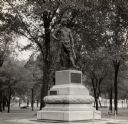
| Description: | Chief Oshkosh's statue and grave. Located in Menominee Park, formerly North Park. |
| Date: | 1935 |
|---|---|
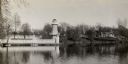
| Description: | Lake Okauchee lighthouse. Buildings are in the background along a tree-covered shoreline. |

| Date: | 1937 |
|---|---|
| Description: | Picnic and play area at Interstate Park, near the St. Croix River. Two girls swing as an adult male sits on a picnic table in the foreground with a child o... |

| Date: | 09 25 1937 |
|---|---|
| Description: | Governor Philip Fox La Follette (center) together with Governors Horner (Illinois) and Kraschel (Iowa) pose in front of the fish they caught during a fishi... |

| Date: | 09 25 1937 |
|---|---|
| Description: | Governor Philip La Follette (Wisconsin) and Governor Henry Horner (Illinois) enjoy a laugh in the boat during a fishing trip. |
| Date: | 1939 |
|---|---|
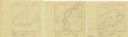
| Description: | A survey map of Island Lake in Bayfield County, Wisconsin, Chain Lake in Rusk and Chippewa counties, and Manson Lake in Oneida County. The maps show the de... |
If you didn't find the material you searched for, our Library Reference Staff can help.
Call our reference desk at 608-264-6535 or email us at: