 Filter: Categories of Wisconsin Historical Images
Filter: Creator Name of Unknown
Filter: County of Dane
Filter: Categories of Wisconsin Historical Images
Filter: Creator Name of Unknown
Filter: County of Dane
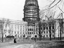
| Date: | 1911 |
|---|---|
| Description: | A view of the construction of the fourth Wisconsin State Capitol. |
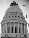
| Date: | 07 20 1914 |
|---|---|
| Description: | The bronze statue "Wisconsin," by Daniel Chester French, is hoisted to the top of the Wisconsin State Capitol dome. |
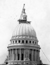
| Date: | 07 20 1914 |
|---|---|
| Description: | A crane places the gilded bronze statue, "Wisconsin," by Daniel Chester French, on top of the Wisconsin State Capitol dome. |
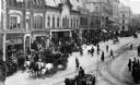
| Date: | 1900 |
|---|---|
| Description: | Pedestrians and a horse and cart at the intersection of Main Street and Monona Avenue (South Wisconsin Avenue until December 1, 1877; Martin Luther King J... |
| Date: | 1893 |
|---|---|
| Description: | Office of the State Board of Control, Wisconsin Reformatory, Charitable and Penal Institutions in the third Wisconsin State Capitol. |
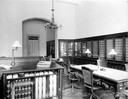
| Date: | 1904 |
|---|---|
| Description: | The remains of a second floor corridor in the North Wing of the Third Wisconsin State Capitol after the fire of February 27-28, 1904. This photograph docum... |
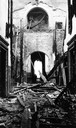
| Date: | 02 27 1904 |
|---|---|
| Description: | The east wing of the third Wisconsin State Capitol is surrounded by onlookers during the disastrous fire that caused severe damage. The conflagration began... |
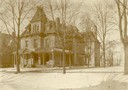
| Date: | 1900 |
|---|---|
| Description: | Wintertime exterior view of 126 Langdon Street, home of J. Howard Palmer and his wife Alice Mears Palmer. |

| Date: | 1910 |
|---|---|
| Description: | Map of Dane County rural delivery in Madison and the town of Westport. |

| Date: | 1836 |
|---|---|
| Description: | Map of all Dane County and eastern towns. |

| Date: | 1839 |
|---|---|
| Description: | A map of the Wiskonsin [sic] and Neenah or Fox Rivers. |

| Date: | 1916 |
|---|---|
| Description: | Map of all automobile roads out of Madison, compliments of the Madison Board Of Commerce. |

| Date: | 1910 |
|---|---|
| Description: | Map of the general plan of the district of the Four Lakes. |
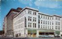
| Date: | 1955 |
|---|---|
| Description: | View of downtown Madison's Park Hotel. The Prescription Pharmacy also occupies a portion of the ground floor. |
| Date: | 1909 |
|---|---|
| Description: | Elevated view of a University of Wisconsin-sponsored parade rolling down Mifflin Street on the Capitol Square. One of the banners appears to be about socia... |
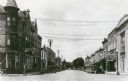
| Date: | 1944 |
|---|---|
| Description: | View of storefronts on Main Street, including a drugstore with soda fountain on the left. |
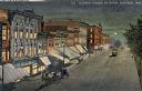
| Date: | 1910 |
|---|---|
| Description: | Elevated view at night of streetcars moving along the Capitol Square on Pinckney Street. Walzinger's Drugstore is one of the prominent storefronts on the l... |
| Date: | 1910 |
|---|---|
| Description: | Group portrait of the crew that constructed the Wisconsin State Capitol dome. The new East Wing is visible in the background. |
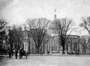
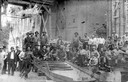
| Date: | 02 15 1899 |
|---|---|
| Description: | The Wisconsin State Assembly in session in the second Wisconsin State Capitol, with observers looking on from the gallery. |

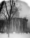
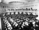
| Date: | 1915 |
|---|---|
| Description: | East Washington Avenue from the Capitol Park with a view of the water tower, which stood from 1890 to 1920. |
If you didn't find the material you searched for, our Library Reference Staff can help.
Call our reference desk at 608-264-6535 or email us at: