Filter: Categories of Wisconsin Historical Images
Filter: Type of Map or Atlas
Filter: Categories of Wisconsin Historical Images
Filter: Type of Map or Atlas

| Date: | 1970 |
|---|---|
| Description: | This colored map displays a brief description of tourist attractions in the state, as well as a grid of state parks and recreational facilities. There is a... |

| Date: | 1966 |
|---|---|
| Description: | This colored road map shows automobile roads in Wisconsin as well as portions of nearby states. A map key indicates relative sizes of cities and towns. On ... |

| Date: | 1966 |
|---|---|
| Description: | This colored road map shows automobile roads in Wisconsin as well as portions of nearby states. Information on the quality and type of any road shown (inte... |

| Date: | 1965 |
|---|---|
| Description: | This colored road map shows automobile roads in Wisconsin as well as portions of nearby states. Information on the quality and type of any road shown (inte... |

| Date: | 1957 |
|---|---|
| Description: | This colored road map shows automobile roads in Wisconsin as well as portions of nearby states. The map is organized such that a single map of Wisconsin is... |

| Date: | 1959 |
|---|---|
| Description: | This colored road map shows roads in Wisconsin as well as portions of nearby states. Information on the quality and type of any road shown (expressways, St... |

| Date: | 1960 |
|---|---|
| Description: | This colored road map shows roads in Wisconsin as well as portions of nearby states. Information on the quality and type of any road shown can be found in ... |

| Date: | 1962 |
|---|---|
| Description: | This colored road map shows roads in Wisconsin as well as portions of nearby states. The map is organized such that a single map of Wisconsin is divided on... |
| Date: | 1962 |
|---|---|
| Description: | This colored road map shows roads in Wisconsin as well as portions of nearby states. The map is organized such that a single map of Wisconsin is divided on... |

| Date: | 1962 |
|---|---|
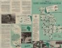
| Description: | This tourist-oriented road map shows federal highways, state highways, county roads, and county lines in the "Blue Diamond Resort Area," a scenic space enc... |

| Date: | 1963 |
|---|---|
| Description: | This colored road map shows automobile roads in Wisconsin as well as portions of nearby states. The map is organized such that a single map of Wisconsin is... |

| Date: | 1962 |
|---|---|
| Description: | This colored map represents "Tour #2" of a series of driving tours of the state published by the Sperry & Hutchinson Company, in order to "help you enjoy W... |

| Date: | 1962 |
|---|---|
| Description: | This colored map represents "Tour #1" of a series of driving tours of the state published by the Sperry & Hutchinson Company, in order to "help you enjoy W... |

| Date: | 1952 |
|---|---|
| Description: | This colored map shows the entire state, along with counties in states bordering Wisconsin. There is a key to "Wisconsin Railroads," with initials identify... |

| Date: | 1952 |
|---|---|
| Description: | This colored map shows the entire state, along with counties in states bordering Wisconsin. There is a key to "Wisconsin Railroads," with initials identify... |

| Date: | 1949 |
|---|---|
| Description: | This multi-colored promotional map for recreational activities in the Hayward area includes a graphic of distances from Midwestern cities to Hayward, with ... |
| Date: | 1953 |
|---|---|
| Description: | This map shows the locations of many scenic areas in La Crosse, Vernon, Crawford, Richland, Grant, and Iowa Counties. On the front side of the map, there i... |

| Date: | 1948 |
|---|---|
| Description: | This colored road map shows automobile roads in Wisconsin as well as portions of nearby states. The map is organized such that a single map of Wisconsin is... |

| Date: | 1948 |
|---|---|
| Description: | This colored road map shows automobile roads in Wisconsin as well as portions of nearby states. The map is organized such that a single map of Wisconsin is... |
If you didn't find the material you searched for, our Library Reference Staff can help.
Call our reference desk at 608-264-6535 or email us at: