 Search: wisconsin
Filter: Subject of breweries
Filter: Year of 1800-1899
Search: wisconsin
Filter: Subject of breweries
Filter: Year of 1800-1899
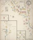
| Date: | 1884 |
|---|---|
| Description: | Sanborn map showing the main street of Potosi, Wisconsin, with an inset for the Potosi Brewery. |

| Date: | 1870 |
|---|---|
| Description: | This 1870 map of Brown County, Wisconsin, shows the township and range grid, towns, sections, cities, villages and post offices, land ownership, roads, rai... |
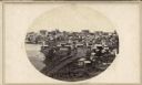
| Date: | 1862 |
|---|---|
| Description: | John S. Fuller took this image of the third Wisconsin State Capitol (the second in Madison), from Governor Farwell's Octagon House, probably early in 1862.... |
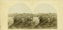
| Date: | 1862 |
|---|---|
| Description: | The third Wisconsin State Capitol (the second in Madison), from Governor Farwell's Octagon House, probably early in 1862. Also visible in the downtown are ... |

| Date: | 1891 |
|---|---|
| Description: | The index page of a Sanborn Map of Stevens Point. |
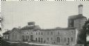
| Date: | 1899 |
|---|---|
| Description: | Exterior view of the Hausmann Brewing Company's Malt House, 1603 Sherman Avenue. |
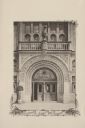
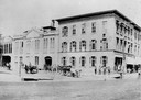
| Date: | 07 03 1886 |
|---|---|
| Description: | The ornate entrance to the Schlitz Palm Garden. Located on N. 3rd Street, south of W. Wisconsin Avenue, the Schlitz Palm Garden opened on July 3, 1886 and ... |

| Date: | 1892 |
|---|---|
| Description: | A Sanborn fire insurance map of Sauk City which was drawn up in 1892. |
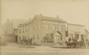
| Date: | 1885 |
|---|---|
| Description: | Exterior view of Fauerbach's Brewery at 651-53 Williamson Street. |

| Date: | 1898 |
|---|---|
| Description: | Bird's-eye map of Milwaukee with prominent streets and buildings identified. Taken from City Hall Tower. |

| Date: | 1882 |
|---|---|
| Description: | This map of Cedarburg is a bird's-eye map with an inset of Cedarburg Brewery. Relief is shown pictorially and the map includes an index to buildings. |
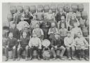
| Date: | 1890 |
|---|---|
| Description: | Brewery workers, posed in front of stacked beer barrels. Pictured (2nd row, far right) is Louis Schreiber (1861-1923) who immigrated to Wisconsin from Bava... |

| Date: | 1878 |
|---|---|
| Description: | Bird's-eye map of Chilton with insets of points of interest, including P.H. Becker's Brewery, Chilton House, and Gutheil's Block. |
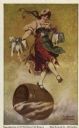
| Date: | 1893 |
|---|---|
| Description: | Reproduction of an oil painting at the Blatz Brewing Company depicting a happy barmaid holding overflowing steins of beer as she dances atop a barrel of Bl... |

| Date: | 1895 |
|---|---|
| Description: | Interior view of the Hausmann Brewery Bar with spittoons on the floor. A sign behind the bar reads: "No intoxicating drinks sold to minors." The patrons an... |

| Date: | 1880 |
|---|---|
| Description: | Bird's-eye map over the Mississippi River of Fountain City. Paddle steamers and steamboats are on the river, and bluffs are in the background. |
| Date: | 1880 |
|---|---|
| Description: | Exterior view of the Haertel Brewery which later became the Eulberg Brewery. |

| Date: | 1891 |
|---|---|
| Description: | Page 13 of a Sanborn map of Stevens Point. |
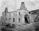
| Date: | 1860 |
|---|---|
| Description: | Exterior view of the Garden City Brewery, built in 1854. A person is on horseback in the yard below on the left, and a man is standing above them in an ope... |
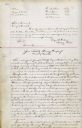
| Date: | 12 19 1873 |
|---|---|
| Description: | The first page of the Joseph Schlitz Brewing Company Articles of Association. |
If you didn't find the material you searched for, our Library Reference Staff can help.
Call our reference desk at 608-264-6535 or email us at: