 Search: wisconsin
Filter: Subject of breweries
Filter: Subject of dwellings
Filter: Subject of church buildings
Search: wisconsin
Filter: Subject of breweries
Filter: Subject of dwellings
Filter: Subject of church buildings
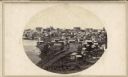
| Date: | 1862 |
|---|---|
| Description: | John S. Fuller took this image of the third Wisconsin State Capitol (the second in Madison), from Governor Farwell's Octagon House, probably early in 1862.... |
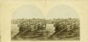
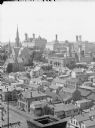
| Date: | 1862 |
|---|---|
| Description: | The third Wisconsin State Capitol (the second in Madison), from Governor Farwell's Octagon House, probably early in 1862. Also visible in the downtown are ... |

| Date: | 1891 |
|---|---|
| Description: | The index page of a Sanborn Map of Stevens Point. |

| Date: | 1900 |
|---|---|
| Description: | A Sanborn fire insurance map of Sauk City created in 1900. |
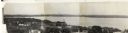
| Date: | 1930 |
|---|---|
| Description: | Panoramic elevated view to the east from the Capitol Square. |

| Date: | 1878 |
|---|---|
| Description: | Bird's-eye map of Chilton with insets of points of interest, including P.H. Becker's Brewery, Chilton House, and Gutheil's Block. |

| Date: | 1880 |
|---|---|
| Description: | Bird's-eye map over the Mississippi River of Fountain City. Paddle steamers and steamboats are on the river, and bluffs are in the background. |
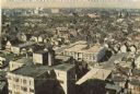
| Date: | 1964 |
|---|---|
| Description: | Elevated view of city looking west, showing breweries and the center of the city. |
| Date: | |
|---|---|
| Description: | View of buildings from the dome of the Exposition building, including a church and the Best Brewing Company in the distance. |
If you didn't find the material you searched for, our Library Reference Staff can help.
Call our reference desk at 608-264-6535 or email us at: