 Search: wisconsin
Filter: Type of Photograph
Filter: Subject of dwellings
Filter: Subject of landforms
Search: wisconsin
Filter: Type of Photograph
Filter: Subject of dwellings
Filter: Subject of landforms

| Date: | 1928 |
|---|---|
| Description: | University of Wisconsin-Madison, looking west. Lake Mendota and Picnic Point are in the upper right of the image. Bascom Hall, the Red Gym, the Wisconsin H... |

| Date: | 1945 |
|---|---|
| Description: | View of the lower campus of the University of Wisconsin-Madison includes Bascom Hill, Wisconsin Historical Society, Memorial Union and the Armory (Red Gym ... |
| Date: | 1899 |
|---|---|
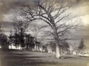
| Description: | View of home atop of Observatory Hill on the University of Wisconsin-Madison campus. |

| Date: | 1908 |
|---|---|
| Description: | Aerial View of University of Wisconsin-Madison College of Agriculture. Lake Mendota with Picnic Point is in the background. |

| Date: | 1900 |
|---|---|
| Description: | Aerial View of University of Wisconsin-Madison College of Agriculture. Lake Mendota with Picnic Point is in the background. |
| Date: | 1925 |
|---|---|
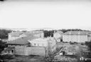
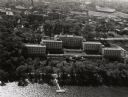
| Description: | Elevated view of dormitories nearing construction completion on the University of Wisconsin-Madison campus. Adams, Van Hise and Tripp Halls are in the fore... |

| Date: | 1910 |
|---|---|
| Description: | Aerial View of University of Wisconsin-Madison College of Agriculture. Lake Mendota with Picnic Point is in the background. |
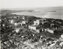
| Date: | 1924 |
|---|---|
| Description: | University of Wisconsin-Madison lower campus and the surrounding neighborhoods. Lake Mendota and Picnic Point are in the background. |
| Date: | 1887 |
|---|---|
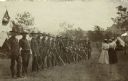
| Description: | Members of the Wisconsin National Guard Light Horse Squadron, Troop A standing in a row. Three women and one man, visitors to Camp Douglas, stand facing th... |

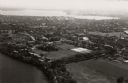
| Date: | 1909 |
|---|---|
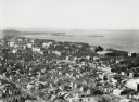
| Description: | View from the University of Wisconsin service building smokestack of south Madison, including Mills Street, Mound Street, and the Greenbush. Lake Monona is... |
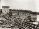
| Date: | 1895 |
|---|---|
| Description: | Munger's Mill and dam, with men standing on and around the dam. |
| Date: | 1924 |
|---|---|
| Description: | University of Wisconsin-Madison aerial view overlooking the lower campus and surrounding neighborhoods. Lake Mendota and Picnic Point are in the background... |

| Date: | 1946 |
|---|---|
| Description: | University of Wisconsin-Madison campus on isthmus, including the Agricultural campus and men's dormitories. Part of Lake Mendota is in the top right corner... |
| Date: | 1946 |
|---|---|
| Description: | View towards southeast of the University of Wisconsin-Madison on isthmus. Lake Mendota is in the lower left corner, and Lake Monona is in the upper portion... |
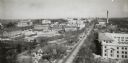
| Date: | 1931 |
|---|---|
| Description: | Tower view from the First Congregational Church of the University campus and University Avenue. Lake Mendota is in the background on the left. The Wisconsi... |

| Date: | |
|---|---|
| Description: | View across water with rocky bluffs rising from the river on the right. A rock formation on the bluff resembles a human profile. In the distance on the lef... |
| Date: | 1947 |
|---|---|
| Description: | Aerial view of the Elizabeth Waters women's dormitory on the University of Wisconsin-Madison campus. In the upper right corner is Camp Randall. A long pier... |

| Date: | 1948 |
|---|---|
| Description: | Aerial view of the Elizabeth Waters women's dormitory on the University of Wisconsin-Madison campus. The dorm is also referred to as "Liz" or "The Rock". A... |

| Date: | 11 1951 |
|---|---|
| Description: | Aerial view of US Highway 14 southeast of La Crosse descending into Mormon Coulee. The original caption of the print, which is undated, describes the road ... |
If you didn't find the material you searched for, our Library Reference Staff can help.
Call our reference desk at 608-264-6535 or email us at:
