 Search: of
Filter: Categories of Wisconsin Historical Images
Search: of
Filter: Categories of Wisconsin Historical Images

| Date: | 1905 |
|---|---|
| Description: | Map of state of Idaho. Department of Interior General Land Office. |
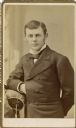
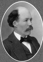
| Date: | 1878 |
|---|---|
| Description: | Carte-de-visite portrait of Frederic King Conover (d. 1919), of Madison, Wisconsin, as a member of the class of 1878 of the University of Wisconsin. |
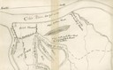
| Date: | 1876 |
|---|---|
| Description: | A map of the site of the Battle of Point Pleasant. |
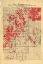
| Date: | 1917 |
|---|---|
| Description: | Map of Barron and parts of Dunn, Chippewa, Washburn & Sawyer counties, State of Wisconsin, showing the lands of the Knapp, Stout & Co. Company, of Menomoni... |
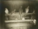
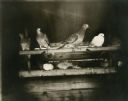
| Date: | 1896 |
|---|---|
| Description: | Group view of several passenger pigeons (possibly other types of pigeon also?), a species of pigeon now extinct. Part of a group of pigeons that lived in c... |
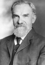
| Date: | |
|---|---|
| Description: | Studio portrait of Robert Schilling, leader of the People's Party of Wisconsin. |

| Date: | 1916 |
|---|---|
| Description: | Map of all automobile roads out of Madison, compliments of the Madison Board Of Commerce. |
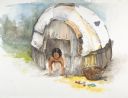
| Date: | 1997 |
|---|---|
| Description: | A watercolor of a shelter made of bark with child inside of it. |

| Date: | 1784 |
|---|---|
| Description: | Map of The United States of America according to the Treaty of Peace of 1784. |

| Date: | 09 16 1958 |
|---|---|
| Description: | Group portrait of the Board of Directors of the State Bar of Wisconsin. |
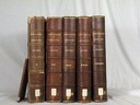
| Date: | 1908 |
|---|---|
| Description: | Five volumes of the Crown Collection of American Maps, plus an index, showing the spines of these books. |

| Date: | 1890 |
|---|---|
| Description: | Portion of a plat map of the "West Part of the City of Madison". |
| Date: | 1890 |
|---|---|
| Description: | Portrait of J.A. Van Cleve, Regent of the University of Wisconsin who helped supervise the construction of the State Historical Society of Wisconsin buildi... |

| Date: | 1848 |
|---|---|
| Description: | Foldout map of a sketch of the town grid of Calumet. |

| Date: | |
|---|---|
| Description: | Interior view of the Chapel of Our Lady of Guadalupe. |

| Date: | 1947 |
|---|---|
| Description: | Collage of photographs of members of the All-American Girls Professional Baseball League, as seen in the Racine Belles annual yearbook of 1948. Clockwi... |

| Date: | 1911 |
|---|---|
| Description: | View of the residence of the Dean of College of Agriculture, 10 Babcock Drive. |
| Date: | 1896 |
|---|---|
| Description: | Seven passenger pigeons (possibly other types of pigeon as well?), a species of pigeon now extinct. Part of a group of pigeons that lived in captivity in t... |
If you didn't find the material you searched for, our Library Reference Staff can help.
Call our reference desk at 608-264-6535 or email us at:

