 Search: fair
Search: buildings
Filter: Type of Map or Atlas
Search: fair
Search: buildings
Filter: Type of Map or Atlas

| Date: | 1860 |
|---|---|
| Description: | Map showing a plat of the city, land ownership by name, wards by number, local streets, buildings, fair grounds, nurseries, and part of Rock River. The map... |

| Date: | 1858 |
|---|---|
| Description: | This map is hand-colored and mounted on cloth and shows lot and block numbers and dimensions, landownership, streets, railroads, selected buildings, fair g... |

| Date: | 06 1959 |
|---|---|
| Description: | This blue line print map shows lot and block numbers and dimensions, fair grounds, schools, court house, parks, and the street numbering system. The Crawfi... |

| Date: | 1889 |
|---|---|
| Description: | This map shows a plat of city, city limits, numbered blocks, numbered lots, wards, local streets, roads, railroads, street railways, fire limits, hydrants,... |

| Date: | 1955 |
|---|---|
| Description: | This blue line print shows streets, fair grounds, schools, parks, and a cemetery. Streets, points of interest, and Lake Marinuka are labeled. The middle le... |
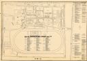
| Date: | 1948 |
|---|---|
| Description: | This map of the Wisconsin Centennial Exposition is oriented with north to the right. The right hand margin includes "Outstanding Events of the Grandstand P... |

| Date: | 1883 |
|---|---|
| Description: | This map shows ward boundaries, names of additions, streets, bridges, mills, schools, religious buildings, businesses, hotels, railroads, factories, brewer... |

| Date: | 1867 |
|---|---|
| Description: | Birds-eye drawing of Beaver Dam, Dodge Co., depicting street names and street layout, houses, rivers, lakes, and trees. A reference key at the bottom of th... |

| Date: | 1870 |
|---|---|
| Description: | Birds-eye drawing of Oconomowoc depicts street names and street layouts, houses, trees, Oconomowoc River, Fowler Lake, and La Belle Lake. A reference key a... |

| Date: | 1927 |
|---|---|
| Description: | This map includes an index and highways marked in red. Attractions on the map include: Four Mile House, Cold Springs, Grand Crossing Station, Coleman Sloug... |
If you didn't find the material you searched for, our Library Reference Staff can help.
Call our reference desk at 608-264-6535 or email us at: