 Search: earth
Filter: Year of 1700-1799
Search: earth
Filter: Year of 1700-1799

| Date: | 1766 |
|---|---|
| Description: | Map of the north western hemisphere using sinusoidal projection to show the curvature of the earth. It labels regions, cities, Native American land, island... |
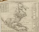
| Date: | 1739 |
|---|---|
| Description: | Map of North America using sinusoidal projection to represent the curvature of the earth. It shows settlements and cities, Native American land, lakes, riv... |

| Date: | 1712 |
|---|---|
| Description: | Engraved double-hemispherical world map by Moll, included in his atlas The world described, or, A new and correct sett of maps: shewing the kingdoms and st... |

| Date: | 1729 |
|---|---|
| Description: | This small and hand-painted map focuses on the English claims in North America along the east coast from Cuba up to the southern tip of Greenland. It shows... |

| Date: | 1791 |
|---|---|
| Description: | Small map of an abandoned Native American town and fort at the junction of the Ohio and Muskingum River. It shows the fortifications, an outline of the tow... |

| Date: | 1760 |
|---|---|
| Description: | Map of North America based upon the cartographic work of de L'Isle. It shows cities, regions, lakes, rivers, Native American land, mountains, islands, and ... |

| Date: | 1746 |
|---|---|
| Description: | This world map from the German mathematician, historian, and geographer Johann Matthias Hase shows the major cities, islands, and the major political divis... |

| Date: | 1766 |
|---|---|
| Description: | This map of North America shows the boundaries of European claims at the end of the French and Indian war. The British colonies extend to the Mississippi. ... |

| Date: | 1719 |
|---|---|
| Description: | Map of North America showing land divisions between France, Spain, England, Sweden, Denmark and Holland. The map is detailed, labeling cities, forts, islan... |

| Pioneer and Hoaxer |
|---|
| Biography of Prairie du Chien pioneer and Wisconsin's "oldest man," Joseph Crelie. |
| Learn about the first extreme winters in Wisconsin suffered by explorers and settlers in the 17th through 19th centuries, with links to other articles |
If you didn't find the material you searched for, our Library Reference Staff can help.
Call our reference desk at 608-264-6535 or email us at: