 Search: Wisconsin
Search: Historical
Filter: Categories of Wisconsin Historical Images
Filter: Subject of tourism
Search: Wisconsin
Search: Historical
Filter: Categories of Wisconsin Historical Images
Filter: Subject of tourism

| Date: | 09 03 1882 |
|---|---|
| Description: | Elevated view of the steamboat Alexander Mitchell and the back of a second unidentified steamboat at a dock. Captain Dave and most of the passengers... |

| Date: | 09 04 1882 |
|---|---|
| Description: | Elevated view across water towards the steamboat Alexander Mitchell moored in the canyon along the shoreline. Captain Dave and passengers are posing... |

| Date: | 09 04 1882 |
|---|---|
| Description: | Elevated view of the steamboat Alexander Mitchell at a dock. Captain Dave and most of the passengers on the lower level are posing standing. There i... |

| Date: | 07 14 1883 |
|---|---|
| Description: | Elevated view from shoreline of the steamboat Alexander Mitchell docked at the edge of the river. Captain Dave and passengers are posing on board. B... |
| Date: | 1886 |
|---|---|
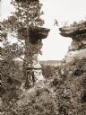
| Description: | Ashley Bennett, son of photographer H.H. Bennett, is captured in mid-air as he jumps to Stand Rock. |
| Date: | 1891 |
|---|---|
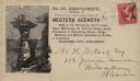
| Description: | H.H. Bennett advertising envelope addressed to William H. Metcalf of Milwaukee. The envelope bears an engraved image of people standing on top of Stand Roc... |

| Date: | 1903 |
|---|---|
| Description: | Group of people on the excursion steamer Eleanor in the Dells. |

| Date: | 1935 |
|---|---|
| Description: | This map shows rivers, lakes, communities, woods, fishing locations, and vacation destinations. The back of the map includes text about agricultural, sceni... |

| Date: | 1938 |
|---|---|
| Description: | This 1938 tourist map of Douglas County, Wisconsin, identifies game refuges, fishing locations, and other outdoor recreation opportunities in the county. A... |

| Date: | 1941 |
|---|---|
| Description: | This pictorial map of Wisconsin with historical text highlights the history of the state and identifies places of interest, Indian villages, missions, trad... |

| Date: | 1945 |
|---|---|
| Description: | Totem Pole Room at the Cave of the Mounds. Caption on back of print reads: "The Totem Pole Room is popular with visitors because of the rich coloring and r... |
| Date: | 1952 |
|---|---|
| Description: | Slightly elevated view of the performance at the Stand Rock Indian Ceremonial. A group of men, women and children are performing the Green Corn Dance, movi... |

| Date: | 1955 |
|---|---|
| Description: | Tony White Cloud performs a Hoop Dance at the Stand Rock Indian Ceremonial. He is dressed in Native American ceremonial clothing. During its 78-year run ... |
| Date: | 08 26 1956 |
|---|---|
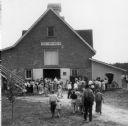
| Description: | Part of a crowd of over 3000 that toured Stonefield, the Historical Society's site at Cassville, during an open house. The building that housed the State ... |

| Date: | 07 09 1958 |
|---|---|
| Description: | Christine and Bill Schuldt admiring posters and relics of circuses founded in Wisconsin at an exhibit in the State Historical Society Museum. The photograp... |

| Date: | 1959 |
|---|---|
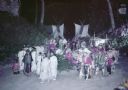
| Description: | Slightly elevated view of Ho Chunk performing at the Stand Rock Indian Ceremonial at night. A group of men, women and children are dancing in a circle, wea... |
| Date: | 1962 |
|---|---|
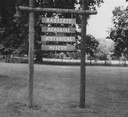
| Description: | Entrance marker to the museum. |

| Date: | 1966 |
|---|---|
| Description: | This colored road map shows automobile roads in Wisconsin as well as portions of nearby states. Information on the quality and type of any road shown (inte... |

| Date: | 1966 |
|---|---|
| Description: | This colored road map shows automobile roads in Wisconsin as well as portions of nearby states. A map key indicates relative sizes of cities and towns. On ... |

| Date: | 1967 |
|---|---|
| Description: | This colored map published by the State Historical Society of Wisconsin shows key points of interest telling the story of Wisconsin's earliest settlement a... |
If you didn't find the material you searched for, our Library Reference Staff can help.
Call our reference desk at 608-264-6535 or email us at: