 Search: Wisconsin
Search: Historical
Filter: Categories of Wisconsin Historical Images
Filter: Subject of mississippi river
Search: Wisconsin
Search: Historical
Filter: Categories of Wisconsin Historical Images
Filter: Subject of mississippi river

| Date: | 1758 |
|---|---|
| Description: | This detailed map of north eastern America shows the boundaries, cities, mountains, rivers, lakes, Native American land and towns, and roads from east of t... |

| Date: | 1829 |
|---|---|
| Description: | Drawing of Cassville depicting a horse cart on the river's edge, with men and boats. |
| Date: | 1875 |
|---|---|
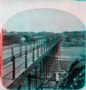
| Description: | "Iron Bridge across Mississippi" photographed during "The Norwegian Lutheran Synod held at Minneapolis, Minn., 1875," as described in Dahl's 1877 "Catalogu... |
| Date: | 1875 |
|---|---|
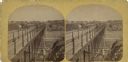
| Description: | "Iron Bridge across Mississippi" photographed during "The Norwegian Lutheran Synod held at Minneapolis, Minn., 1875," as described in Dahl's 1877 "Catalogu... |

| Date: | 1878 |
|---|---|
| Description: | Illustrated map of Crawford County. On the bottom right is an inset of a group of people near a train on a railroad track. |

| Date: | 1880 |
|---|---|
| Description: | Alma was platted and settled in 1855, on a narrow strip of land between high bluffs and the Mississippi River. Its location made it a popular shipping cent... |

| Date: | 1882 |
|---|---|
| Description: | This map is ink on cardboard and shows the location of military forts over the course of years. Also shown are points of interest, streets, the Mississippi... |
| Date: | 1890 |
|---|---|
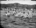
| Description: | View across water towards men and boys swimming and splashing in the Mississippi River. Alma is in the background on the far shoreline. |

| Date: | 1895 |
|---|---|
| Description: | View across water towards a house on the banks of the Mississippi River at the base of rocky bluffs. Probably located between Alma and Nelson, along Beef S... |

| Date: | 1900 |
|---|---|
| Description: | This set of photocopy bird's-eye-view maps include one view looking west from the top of Wisconsin River bluffs; and a second view looking east towards La ... |
| Date: | 1910 |
|---|---|
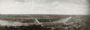
| Description: | Panoramic photographic view of Burlington, taken with a local Al-vista panoramic camera. |

| Date: | 1910 |
|---|---|
| Description: | Five men posing in front of the floating fish market, which is on the shore of the Mississippi River. One of the men is holding a large buffalo fish. The m... |
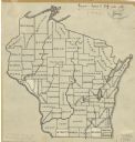
| Date: | 1912 |
|---|---|
| Description: | An ink and pencil on paper map of Wisconsin that shows contemporary county divisions in the state. The map depicts the locations of some of the rivers that... |

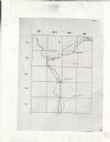
| Date: | 1919 |
|---|---|
| Description: | Narrow red lines show principal secondary highways. Green circles shows points of historical interest. Green triangles show Indian mounds and Indian villag... |
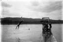
| Date: | 1925 |
|---|---|
| Description: | A man diving off a pier into the Mississippi River. Another man is swimming in the water, while other men and boys are standing on the floating pier. |

| Date: | 01 15 1929 |
|---|---|
| Description: | Intended for tourists, this brochure, titled: "Winneshiek World’s Famous Wild Life Refuge Historic Fort Crawford and Picturesque Prairie du Chien," feature... |

| Date: | 1937 |
|---|---|
| Description: | Pictorial map showing historical events and locations within the state of Wisconsin, as well as waterways and counties. Original caption on the bottom marg... |
| Date: | 1949 |
|---|---|
| Description: | This map is comprised of six plates that depict the rout the Sauks and Meskwakis, led by Black Hawk, took through Wisconsin during the Black Hawk War of 18... |

| Date: | 1949 |
|---|---|
| Description: | This pictorial map shows the United States west of the Mississippi, including Indian Tribes, historic trails, forts, trading posts, mountain ranges, lakes ... |
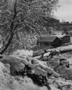
| Date: | 1950 |
|---|---|
| Description: | A boathouse, boat and pier on the frozen shoreline of the Mississippi River. More buildings appear in the background, a snow covered tree on the left and a... |
If you didn't find the material you searched for, our Library Reference Staff can help.
Call our reference desk at 608-264-6535 or email us at: