 Search: Wisconsin
Search: Historical
Filter: Categories of Wisconsin Historical Images
Filter: Subject of maps
Search: Wisconsin
Search: Historical
Filter: Categories of Wisconsin Historical Images
Filter: Subject of maps

| Date: | 1758 |
|---|---|
| Description: | This detailed map of north eastern America shows the boundaries, cities, mountains, rivers, lakes, Native American land and towns, and roads from east of t... |
| Date: | 1857 |
|---|---|
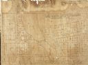
| Description: | Plat map of Kekoskee, Wisconsin. Kekoskee is a village in Dodge County, in the Beaver Dam metropolitan area. The community name derives from Indian term fo... |

| Date: | 1862 |
|---|---|
| Description: | Birds-eye view of a Wisconsin Civil War regiment on parade in Fond du Lac, as drawn by Louis Kurz from the Marr Street Methodist Church. The regiment canno... |
| Date: | 1878 |
|---|---|
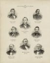
| Description: | This print shows eight former Governors of Wisconsin. In date order: "Louis P. Harvey, 1862 til April 20"; "Edward Salomon, April 20 1862-1864"; "James T. ... |

| Date: | 1878 |
|---|---|
| Description: | This map shows ward boundaries in red, as well as counties, communities, rivers, lakes, Lake Michigan, and Lake Superior. The bottom left corner includes a... |

| Date: | 1878 |
|---|---|
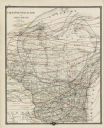
| Description: | This map shows 13 districts throughout the state. Congressional districts are outlined in red and judicial districts are outlined in blue as show borders a... |
| Date: | 1878 |
|---|---|
| Description: | This map shows climate information for an entire year with an explanation key in the lower left corner of colors: Mean Temperature for the Year (red), Mean... |

| Date: | 1878 |
|---|---|
| Description: | This map shows geographic regions of the entire state. The bottom left corner includes an "Explanation of Color": Laurentien Granite (pink), Huronian Iron-... |

| Date: | 1878 |
|---|---|
| Description: | This lithograph shows Africa, Europe, Asia, Australia, and the Antarctic Continent, the Atlantic Ocean, the Indian Ocean, the Arctic Ocean, the Pacific Oce... |

| Date: | 1878 |
|---|---|
| Description: | This lithograph shows Greenland, North America, Central America, South America, Polynesia, Australia, the Pacific Ocean, the Atlantic Ocean, the Arctic Oce... |
| Date: | 1903 |
|---|---|
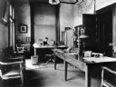
| Description: | Interior view of the State Historical Society Library Superintendent's office with Reuben Gold Thwaites seated at his desk. There is a map of the United St... |

| Date: | 1925 |
|---|---|
| Description: | This map shows trails, mounds, villages, corn fields, and contemporary civil townships; some villages and features include both Indian and English place na... |

| Date: | 1930 |
|---|---|
| Description: | Exterior view of the Triangle filling station on Highway 12, which sold gasoline, ice, and other items. A man stands in front by the gas pump, and a map of... |
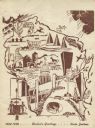
| Date: | 1948 |
|---|---|
| Description: | Holiday card of the history of the State of Wisconsin, 1848-1948. Shows a map of Wisconsin with many historical and themed elements. Image was created by w... |
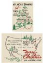
| Date: | 1950 |
|---|---|
| Description: | Holiday card with the "family tree" of D.C. III (David Clark Everest) and Rita Everest, on the front, and a map of the U.S.A. on the inside showing the two... |

| Date: | 1952 |
|---|---|
| Description: | Map of the barley-growing regions of North America, published by the Rahr Malting Company, Manitowoc, Wisconsin, 1952. |

| Date: | 1954 |
|---|---|
| Description: | State Historical Society of Wisconsin staff enjoying a fun moment and posing with a map of Wisconsin and a gnome statue. Left to right: John Jacques, Cliff... |
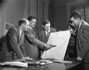
| Date: | 1954 |
|---|---|
| Description: | Four men are standing around a desk looking at a map of Wisconsin marked with the county borders. Clifford Lord is pointing at the map with a tobaco pipe. ... |
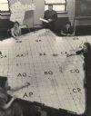
| Date: | 1955 |
|---|---|
| Description: | Elevated view of four women sitting, and one man standing, around a large map of northeast Wisconsin and Michigan's Upper Peninsula. The women are wearing ... |

| Date: | 1957 |
|---|---|
| Description: | Two children are standing and looking at an exhibit that features tools, a map, and some text. Caption reads: "Visitors in the pioneer gallery of the State... |
If you didn't find the material you searched for, our Library Reference Staff can help.
Call our reference desk at 608-264-6535 or email us at: