 Search: War
Filter: Categories of Wisconsin Historical Images
Filter: Year of 1800-1899
Search: War
Filter: Categories of Wisconsin Historical Images
Filter: Year of 1800-1899
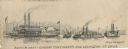
| Date: | 1863 |
|---|---|
| Description: | Four boats shown. One is a repair boat and the other two the gunboats "Cincinnatti" [sic] and "Lexington." There is a steamboat marked "Marie Denin"... |
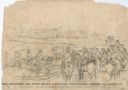
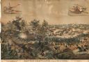
| Date: | 10 03 1862 |
|---|---|
| Description: | "General Rosecranz and staff huredly [sic] erecting earthworks during the Battle at Corinth. The enemy driving in our lines." Men are on horses on a... |
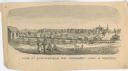
| Date: | 1861 |
|---|---|
| Description: | "View of Springfield, MO. Frmonts [sic] Army in Possesion [sic]." Several people and a horse are in the foreground, and city buildings are in... |
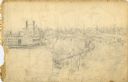
| Date: | 1862 |
|---|---|
| Description: | This is the preliminary sketch for "Hamburg Landing, 4 miles below Pittsburg Landing, Commisary [sic] Depot of Gen. Hallek's Army." Shows an encampm... |

| Date: | 08 10 1862 |
|---|---|
| Description: | A hand-drawn map of the Battle of Wilson's Creek, Springfield, Missouri. Other notes and locations include: "Lyon was killed instantly while heading his tr... |

| Date: | 1864 |
|---|---|
| Description: | Fort Crawford was decommissioned in 1856, having outlived its usefulness as a frontier post. During the Civil War, however, it functioned as a military ho... |
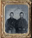
| Date: | 1865 |
|---|---|
| Description: | Sixth plate ferrotype/tintype of William H. Cheney (?) and Lyman Richardson. Half length portrait, seated, facing forward, wearing their Civil War uniforms... |

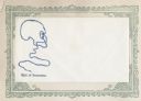
| Date: | 1881 |
|---|---|
| Description: | Oval-framed waist-up portrait of Lars K. Aaker, a Norse immigrant, farmer, Civil War veteran and Minnesota state legislator. He emigrated to the United Sta... |
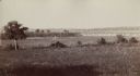
| Date: | 1890 |
|---|---|
| Description: | View of the field where Pickett's charge took place during the Battle of Gettysburg. |
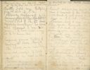
| Date: | 07 01 1863 |
|---|---|
| Description: | A two page diary entry written at the Gettysburg battlefield by Rufus R. Dawes. |
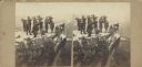
| Date: | 1864 |
|---|---|
| Description: | Albumen stereograph of the Union Army brass band posed and playing atop Lookout Point. The Tennessee River is in the background. |
| Date: | 1888 |
|---|---|
| Description: | Lithographed advertising poster showing the Civil War Battle of Atlanta. Produced for the McCormick Harvesting Machine Company, the poster features insets ... |
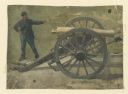
| Date: | 1886 |
|---|---|
| Description: | Oil on linen study of a Union Civil War soldier firing a cannon. The painting was done by one of a group of German panorama painters active in Milwaukee d... |
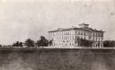
| Date: | 1865 |
|---|---|
| Description: | View across open grounds towards the Brisbois Hotel, built in the early 1860's, and used as a hospital during the Civil War. It was later part of Campion H... |
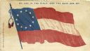
| Date: | 1861 |
|---|---|
| Description: | The first national flag of the Confederacy (Stars and Bars) and the slogan: "We are in the field, and the bars are up!" Red and blue ink on cream envelope,... |

| Date: | 1844 |
|---|---|
| Description: | Group of men engaged in a war dance. They hold spears, axes, and bows. (Plate 29) |
| Date: | 1860 |
|---|---|
| Description: | Piece of rope with one end tied in the form of a noose, depicting a skull. Caption below reads: "End of Secession." Blue ink, illustration on right side of... |
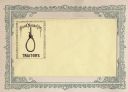
| Date: | 1860 |
|---|---|
| Description: | A rope is tied in a noose inside of a frame. Caption reads: "Good Noose for TRAITORS." Black ink on yellow envelope, illustration is on left side. Mounted ... |
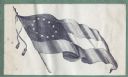
| Date: | 1860 |
|---|---|
| Description: | The Confederate flag. Pro-Confederate envelopes were not as common as pro-Union envelopes. Black ink on beige envelope, image covers entire front. Image p... |

| Date: | 1863 |
|---|---|
| Description: | A general map of the southeastern United States showing Missouri, Kentucky, West Virginia, Virginia, North Carolina, South Carolina, Georgia, Florida, Alab... |
If you didn't find the material you searched for, our Library Reference Staff can help.
Call our reference desk at 608-264-6535 or email us at: