Search: War
Filter: Categories of Wisconsin Historical Images
Filter: Year of 1800-1899
Filter: Subject of roads
Search: War
Filter: Categories of Wisconsin Historical Images
Filter: Year of 1800-1899
Filter: Subject of roads

| Date: | 1864 |
|---|---|
| Description: | This map created during the Civil War indicates Confederate fortifications, houses, names of residents, towns, roads, railroads, relief by hachures, draina... |
| Date: | 1865 |
|---|---|
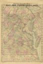
| Description: | A general map of eastern Virginia, Maryland, Delaware, southern Pennsylvania, and northern North Carolina. |

| Date: | 1862 |
|---|---|
| Description: | This map of eastern Virginia and Maryland shows rivers, roads and railroads from Hagerstown, Maryland, south to Suffolk, Virginia, and west to Staunton, Vi... |
| Date: | 1890 |
|---|---|
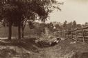
| Description: | Site of the Battle of Antietam. The bloody lane. |

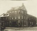
| Date: | 1898 |
|---|---|
| Description: | View from across street of the exterior of a large hall with plate glass windows welcoming returning troops from the Spanish-American War. Soldiers and oth... |
| Date: | 1871 |
|---|---|
| Description: | Stereograph of exterior of a building used as the Confederate government's Executive Mansion. This was where Jefferson Davis and his family stayed during t... |

| Date: | 1862 |
|---|---|
| Description: | Birds-eye view of a Wisconsin Civil War regiment on parade in Fond du Lac, as drawn by Louis Kurz from the Marr Street Methodist Church. The regiment canno... |
| Date: | 1890 |
|---|---|
| Description: | View across road towards the house where General Reynolds' body was taken after he was killed on the first day of the Battle of Gettysburg. |

| Date: | 1864 |
|---|---|
| Description: | Map of eastern Virginia and part of Maryland, showing engagements by crossed swords, fortifications surrounding Richmond, routes of the opposing armies fro... |

| Date: | 1865 |
|---|---|
| Description: | This map of Maryland and Virginia shows railroads, rivers, cities and towns, and the positions of Confederate troops and defenses in Virginia in 1861. |

| Date: | 1861 |
|---|---|
| Description: | A general map of Pennsylvania, Virginia, New Jersey and Delaware. Insets include maps of New Orleans, Baltimore, St. Louis, Charleston, Savannah, Washingto... |
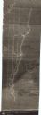
| Date: | 1840 |
|---|---|
| Description: | This map shows shows three routes; a route surveyed by Doty & Center, a route surveyed by inhabitants of East Milwaukee, and a route surveyed by inhabitant... |
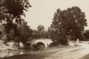
| Date: | 1890 |
|---|---|
| Description: | Site of the Battle of Antietam, the Burnside Bridge. |
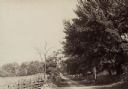
| Date: | 1890 |
|---|---|
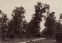
| Description: | Hagerstown Pike. A brick wall and trees are along the road on the right. |

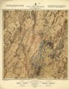
| Date: | 1876 |
|---|---|
| Description: | Detailed topographic map of the Gettysburg battlefield created thirteen years after the battle. This map shows day one of the battle. The map shows drainag... |
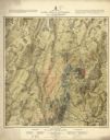
| Date: | 1876 |
|---|---|
| Description: | Detailed topographic map of the Gettysburg battlefield created thirteen years after the battle. This map shows day two of the battle. The map shows drainag... |
| Date: | 1876 |
|---|---|
| Description: | Detailed topographic map of the Gettysburg battlefield created thirteen years after the battle. This map shows day three of the battle. The map shows drain... |

| Date: | 1864 |
|---|---|
| Description: | This battlefield map of the Battle of Totopotomoy Creek, also known as the Battle of Bethesda Church, shows the railroads, roads, vegetation and topography... |
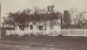
| Date: | 1864 |
|---|---|
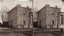
| Description: | Marshall House, in which Col. E.E. Ellsworth was shot on May 24, 1861. |
If you didn't find the material you searched for, our Library Reference Staff can help.
Call our reference desk at 608-264-6535 or email us at: