 Search: War
Filter: Categories of Wisconsin Historical Images
Filter: Year of 1800-1899
Filter: Subject of maps
Search: War
Filter: Categories of Wisconsin Historical Images
Filter: Year of 1800-1899
Filter: Subject of maps
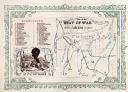
| Date: | 1860 |
|---|---|
| Description: | African American man, left, map depicting Maryland, Virginia, Delaware and the border of Pennsylvania, right. Key of "DIRECTIONS" in upper right corner. At... |
| Date: | 04 06 1862 |
|---|---|
| Description: | A hand-drawn map of the Battle of Shiloh, Pittsburg Landing, Tennessee. Additional Notes include "Reserve Artillery," "Hospital," "Owl Creek," and "Snake C... |

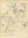
| Date: | 08 10 1862 |
|---|---|
| Description: | A hand-drawn map of the Battle of Wilson's Creek, Springfield, Missouri. Other notes and locations include: "Lyon was killed instantly while heading his tr... |

| Date: | 1862 |
|---|---|
| Description: | Birds-eye view of a Wisconsin Civil War regiment on parade in Fond du Lac, as drawn by Louis Kurz from the Marr Street Methodist Church. The regiment canno... |

| Date: | 12 26 1862 |
|---|---|
| Description: | Handsketched map of the area around Knobs Gap. |
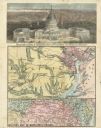
| Date: | 08 1861 |
|---|---|
| Description: | Large-format, illustrated stationery purchased by Rudolph Fine, a member of the 6th Wisconsin Infantry in August, 1861, showing the Capitol (in actuality, ... |
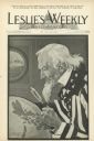
| Date: | 06 09 1898 |
|---|---|
| Description: | Cover art for Leslie's Weekly depicting Uncle Sam peering through a magnifying glass at the Philippine Islands on a globe. The caption reads: "Guess... |
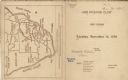
| Date: | 11 14 1899 |
|---|---|
| Description: | Front and back covers of the first dinner of the Six O'Clock Club held at the Park Hotel, with a map on the back cover of the southern tip of Africa, with ... |
If you didn't find the material you searched for, our Library Reference Staff can help.
Call our reference desk at 608-264-6535 or email us at: