 Search: War
Filter: Categories of Wisconsin Historical Images
Filter: Subject of coasts
Search: War
Filter: Categories of Wisconsin Historical Images
Filter: Subject of coasts

| Date: | 1781 |
|---|---|
| Description: | Map of North and South Carolina and Virginia towards the end of the Revolutionary War. It shows borders, counties, cities, court houses, bridges, chapels, ... |

| Date: | 1780 |
|---|---|
| Description: | Map of North America east of Mexico showing colonial boundaries, forts, cities, Native American land, mountains, waterfalls, lakes, and rivers. Short notes... |

| Date: | 1763 |
|---|---|
| Description: | Map showing the new British territories of East and West Florida following the Treaty of Paris at the end of the French and Indian War. It shows boundaries... |
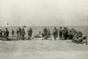
| Date: | 11 13 1942 |
|---|---|
| Description: | Headquarters of the 32nd American Division, on the beach at Pongani, northeast New Guinea. |

| Date: | 1776 |
|---|---|
| Description: | Map showing the English claims in America at the outbreak of the Revolutionary War. Lotter labels each of the thirteen colonies (both in the map and in the... |

| Date: | 1759 |
|---|---|
| Description: | Map of New Orleans at the start of the French & Indian War, including two inset maps entitled "The Course of the Mississipi River from Bayagoulas to the Se... |

| Date: | 1769 |
|---|---|
| Description: | Map of New Orleans at the start of the French & Indian War, including two inset maps of the Mississippi River Delta and Fort la Balise. It shows streets, r... |

| Date: | 1777 |
|---|---|
| Description: | This detailed map of the American colonies shows cities, villages, roads, mountains, lakes, rivers, swamps, counties, state boundaries, and Native American... |
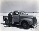
| Date: | 1943 |
|---|---|
| Description: | Two uniformed men sit inside an International K-1 U.S. Coast Guard truck parked on a beach while another man speaks to them through the open passenger door... |
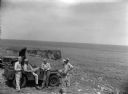
| Date: | 1945 |
|---|---|
| Description: | Leota Kelly, directer of the Pacific Athletic Club, division of the Red Cross, and colleagues, at the site of the new Red Cross Club in Tinian near a cliff... |

| Date: | 1902 |
|---|---|
| Description: | This map is a chart of Milwaukee Harbor that displays local streets, bridges, roads, railroads, public buildings, businesses, factories, dry docks, parks, ... |

| Date: | 10 1776 |
|---|---|
| Description: | Broadside map showing the British invasion of New York city in August and September of 1776. The map shows important cities, forts, roads, hills, mountains... |
If you didn't find the material you searched for, our Library Reference Staff can help.
Call our reference desk at 608-264-6535 or email us at: