 Search: LIGHTHOUSES

| Date: | |
|---|---|
| Description: | A view of the Charlotte-Genesee Lighthouse, constructed in 1822 on a hill just west of the Genesee River, covered in vines. This light was built in 1822 (n... |
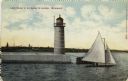
| Date: | 1910 |
|---|---|
| Description: | Hand-colored postcard view of a pier and lighthouse at the entrance to Milwaukee's harbor. Two people sail in a small boat to the right of the lighthouse, ... |

| Date: | 01 07 1958 |
|---|---|
| Description: | View from the Second Street bridge over the icy Ahnapee River towards Lake Michigan. A lighthouse is at the end of a jetty in the far background. Boats are... |

| Date: | 1905 |
|---|---|
| Description: | This map shows railroads, towns, lights, lights to be established, fog signals, light-vessels, lighted buoys, light-house depots, and light-house reservati... |

| Date: | 1940 |
|---|---|
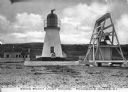
| Description: | A log gate and log-framed sign mark the entrance to the Twin River (Rawley) Point lighthouse. The keeper's house is next to the light and has a turret and ... |
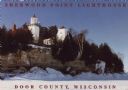
| Date: | 1963 |
|---|---|
| Description: | Text on front reads: "Sherwood Point Lighthouse, Door County, Wisconsin." On reverse: "Sherwood Point Lighthouse is near Potawatomi State Park, north of St... |
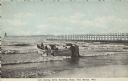
| Date: | 1907 |
|---|---|
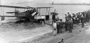
| Description: | Text on front reads: "Life Saving Crew Entering Boat, Two Rivers, Wis." A group of men launching a large rowboat into Lake Michigan. In the background is a... |
| Location: | Pilot Island |
|---|---|
| Nearby City: | Death's Door Passage, Door County |
| Body of water: | Lake Michigan |
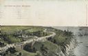
| Date: | |
|---|---|
| Description: | Elevated view with the lake on the right, with a number of boats near the shoreline. There is a long winding road through the park, including bridges, a fo... |

| Date: | 1838 |
|---|---|
| Description: | Territorial seal of Wisconsin. There is a farmer in the foreground plowing behind horses, a Native American apparently heading west, a river steamboat and ... |
| Date: | 1908 |
|---|---|
| Description: | A view of the Prudence Island granite lighthouse, established in 1852 and automated in 1972, more commonly known locally as the Sandy Point Lighthouse. The... |

| Date: | 01 08 1958 |
|---|---|
| Description: | View of Two Rivers Harbor from shoreline towards Lake Michigan. Snow is on the ground, and a fence made of thick posts and cable is along the shoreline on ... |

| Date: | 1940 |
|---|---|
| Description: | A man is standing and looking at the door of the boathouse on the beach near the Twin River (Rawley) Point Lighthouse. The boathouse has stone sides and a ... |
| Date: | 1963 |
|---|---|
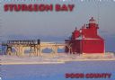
| Description: | Text on front reads: "Sturgeon Bay, Door County." On reverse: "Sturgeon Bay, Wisconsin, Door County. North Pierhead Light. Winter shows its pretty face on ... |

| Date: | 1963 |
|---|---|
| Description: | Text on front reads: "Sherwood Point Lighthouse, Door County." On reverse: "Built in 1883, the Sherwood Point Lighthouse marks the entrance into Sturgeon B... |

| Date: | 03 23 1915 |
|---|---|
| Description: | Text on front reads: "Steamship William E. Corey, entering Duluth and Superior Harbor, Wis." A steamship entering the harbor under the Aerial Lift Bridge, ... |
| Date: | 1929 |
|---|---|
| Description: | A Loening Amphibian, one of three such airplanes in which the Kohler Aviation Company provided passenger service from Milwaukee across Lake Michigan. |

| Date: | 1871 |
|---|---|
| Description: | Engraved view of Kenosha harbor. A group of men fish from a pier in the foreground while several boats float through the harbor. A tug is pulling a large s... |

| Date: | 1909 |
|---|---|
| Description: | This 1909 chart of the Apostle Islands, Chequamegon Bay, and the Lake Superior shoreline shows relief by contours and spot heights and depths by contours, ... |
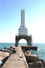
| Community: | Port Washington |
|---|---|
| County: | Ozaukee |
| Historic Name: | Port Washington North Breakwater Light |
| Reference Number: | 100003160 |
If you didn't find the material you searched for, our Library Reference Staff can help.
Call our reference desk at 608-264-6535 or email us at: