 Search: LIGHTHOUSES
Filter: Year of 1900-1999
Filter: Year of 1920-1929
Search: LIGHTHOUSES
Filter: Year of 1900-1999
Filter: Year of 1920-1929
| Date: | 1920 |
|---|---|
| Description: | The Cana Island Lighthouse and keeper's house as seen across the rocky shoreline. |

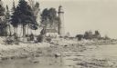
| Date: | 1920 |
|---|---|
| Description: | View from beach across Spike Horn Bay towards Cana Island and the Cana Island Light. |
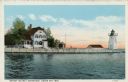
| Date: | 1920 |
|---|---|
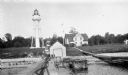
| Description: | View across water toward the lighthouse. Caption reads: "Grassy Island Lighthouse, Green Bay, Wis." |
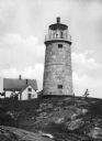
| Date: | 1920 |
|---|---|
| Description: | A view of the Monhegan Island granite lighthouse, built in 1850 and automated in 1959, with the keeper's house close by, which was originally erected in 18... |
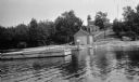
| Date: | 1920 |
|---|---|
| Description: | View from water of a man with a beard standing on a pier near a small boathouse. In the background is a lighthouse with keeper's house and outbuilding. |

| Date: | 1928 |
|---|---|
| Description: | Inside of Tuesday luncheon menu for the "South American." Includes drawings of Niagara Falls, New York, Old Fort Mackinac Island, Michigan, Michigan Boulev... |
| Date: | 1927 |
|---|---|
| Description: | View of the Plum Island rear range lighthouse from the end of the pier. The brick house was home to the lighthouse keeper and the first and second assistan... |
| Date: | 1927 |
|---|---|
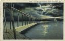
| Description: | Hand-colored postcard view of a pier and lighthouse at night. The moon shines through clouds, and light shines in two directions from the beacon on top of ... |

| Date: | 1927 |
|---|---|
| Description: | A switchback path leading to Cap Carbon and the lighthouse perched near the summit of the peninsula. The lighthouse is built on top of a giant rock that pr... |
| Date: | 1929 |
|---|---|
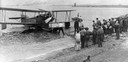
| Description: | A Loening Amphibian, one of three such airplanes in which the Kohler Aviation Company provided passenger service from Milwaukee across Lake Michigan. |

| Date: | 04 1926 |
|---|---|
| Description: | This blueprint mostly shows various numbers within the canal and bay. Lake Michigan and Harobor of Refuge are shown along the far right side. Near the harb... |
If you didn't find the material you searched for, our Library Reference Staff can help.
Call our reference desk at 608-264-6535 or email us at: