 Search: LIGHTHOUSES
Filter: Year of 1900-1999
Filter: Year of 1900-1909
Filter: Subject of cities and towns
Search: LIGHTHOUSES
Filter: Year of 1900-1999
Filter: Year of 1900-1909
Filter: Subject of cities and towns

| Date: | 1905 |
|---|---|
| Description: | This early 20th century map of Door County, Wisconsin, shows the township and range grid, towns, sections, cities and villages, landownership and acreages,... |

| Date: | 1905 |
|---|---|
| Description: | Long Tail Lighthouse and surrounding buildings. |

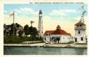
| Date: | 1900 |
|---|---|
| Description: | A view of the lighthouse and dock office at Peshtigo Harbor. |
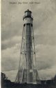
| Date: | 1908 |
|---|---|
| Description: | Postcard view of the tower. Caption reads: "Sturgeon Bay Canal Light Tower." |

| Date: | 12 22 1908 |
|---|---|
| Description: | Text reads: "Views of Racine, Wis." A collage of 12 postcards with views of buildings, landmarks and ships. |

| Date: | 07 24 1906 |
|---|---|
| Description: | Caption reads: "Lighthouse, White Lake." This lighthouse is located in Whitehall, Michigan, between Lake Michigan and White Lake. It was built in 1875 and ... |
| Date: | 1900 |
|---|---|
| Description: | View of the coast guard station from the water with multiple sailors lined up near the shore. Caption reads: "Coast Guard Station, Sturgeon Bay, Door Count... |

| Date: | 1907 |
|---|---|
| Description: | Text on front reads: "Ice Scene on the Pier, Sheboygan, Wis." Ice streamers hang from a pier leading to a lighthouse on Lake Michigan's shore. |

| Date: | 1908 |
|---|---|
| Description: | A detailed map of Michigan Island and Gull Island in the Apostle Islands group (T51N, R1W, 4 M) that shows sections, landowners, the Michigan Island Lighth... |

| Date: | 1905 |
|---|---|
| Description: | This map shows railroads, towns, lights, lights to be established, fog signals, light-vessels, lighted buoys, light-house depots, and light-house reservati... |

| Date: | 1900 |
|---|---|
| Description: | This blue line print map shows land use, cables, U.S.L.S.S. walk and clearing, and front and rear range lights on the Porte des Morts Passage. Tree types a... |

| Date: | 1905 |
|---|---|
| Description: | This map shows railroads, towns, lights, lights to be established, fog signals, light-vessels, lighted buoys, light-house depots, and light-house reservati... |
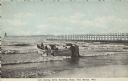
| Date: | 1907 |
|---|---|
| Description: | Text on front reads: "Life Saving Crew Entering Boat, Two Rivers, Wis." A group of men launching a large rowboat into Lake Michigan. In the background is a... |

| Date: | 1905 |
|---|---|
| Description: | This map shows railroads, towns, lights, lights to be established, fog signals, light-vessels, lighted buoys, light-house depots, and light-house reservati... |

| Date: | 1908 |
|---|---|
| Description: | This map shows railroads, towns, lights, lights to be established, fog signals, light-vessels, lighted buoys, light-house depots, and light-house reservati... |
If you didn't find the material you searched for, our Library Reference Staff can help.
Call our reference desk at 608-264-6535 or email us at: