 Search: LIGHTHOUSES
Filter: Subject of transportation
Search: LIGHTHOUSES
Filter: Subject of transportation

| Date: | 04 1926 |
|---|---|
| Description: | This blueprint mostly shows various numbers within the canal and bay. Lake Michigan and Harobor of Refuge are shown along the far right side. Near the harb... |
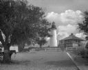
| Date: | 1905 |
|---|---|
| Description: | View along a sandy pathway toward the Amelia Island lighthouse near the keeper's house. Trees line the pathway, and two horses pulling a carriages are on t... |

| Date: | 1856 |
|---|---|
| Description: | The Ludemann's [also spelled Lueddemann] farm had been cultivated since the early 1850s by Mr. Ludemann, "a very pleasant Saxon with his very pleasant wife... |
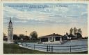
| Date: | |
|---|---|
| Description: | Hand-colored postcard view of the lighthouse and boathouse at Bray's Point. Caption reads: "Bray's Point and Light, Junction of Fox River with Lake Winneba... |
If you didn't find the material you searched for, our Library Reference Staff can help.
Call our reference desk at 608-264-6535 or email us at: