Search: LIGHTHOUSES
Filter: Subject of transportation
Filter: Creator Name of Unknown
Filter: Subject of human settlements
Search: LIGHTHOUSES
Filter: Subject of transportation
Filter: Creator Name of Unknown
Filter: Subject of human settlements

| Date: | 1946 |
|---|---|
| Description: | Map of Kewaunee County, Wisconsin, shows towns, cities and villages, roads and highways, railroads, schools, lighthouses, place names, town divisions, comm... |
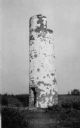
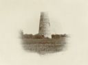
| Date: | 1910 |
|---|---|
| Description: | View of the remnants of the Minnesota Point Lighthouse. Faint caption at bottom reads: "Lighthouse". |

| Date: | 1913 |
|---|---|
| Description: | View of the canal. Caption reads: "The Canal, Stugeon[sic] Bay, Wis." |

| Date: | 1960 |
|---|---|
| Description: | This mid-20th century tourist brochure for Bayfield County, Wisconsin, includes a map of the county showing towns, cities and villages, highways and roads,... |

| Date: | 1967 |
|---|---|
| Description: | This tourist brochure for Bayfield County, Wisconsin, from 1967 includes a map of the county showing towns, cities and villages, highways and roads, railro... |
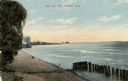
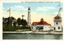
| Date: | 1910 |
|---|---|
| Description: | View of the main pier and harbor lighthouse from the Lake Michigan shoreline. Caption reads: "Bay and Pier, Racine, Wis." |

| Date: | 12 22 1908 |
|---|---|
| Description: | Text reads: "Views of Racine, Wis." A collage of 12 postcards with views of buildings, landmarks and ships. |
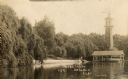
| Date: | 1910 |
|---|---|
| Description: | View of the north shore of Delavan Lake with a lighthouse in the background. Also known as "Red Top" and "L.P. Sutter's." Caption reads: North Shore, Delav... |

| Date: | 1928 |
|---|---|
| Description: | Inside of Tuesday luncheon menu for the "South American." Includes drawings of Niagara Falls, New York, Old Fort Mackinac Island, Michigan, Michigan Boulev... |
| Date: | 1900 |
|---|---|
| Description: | View of the coast guard station from the water with multiple sailors lined up near the shore. Caption reads: "Coast Guard Station, Sturgeon Bay, Door Count... |

| Date: | 07 04 1931 |
|---|---|
| Description: | Inside of Saturday dinner menu for the "North American." Includes drawings of Niagara Falls, New York, Old Fort Mackinac Island, Michigan, Michigan Bouleva... |

| Date: | 01 06 1958 |
|---|---|
| Description: | View from jetty out towards Lake Michigan entrance to Ship Canal. A large tank, streetlamp and buildings are on the left. On the opposite jetty is a lighth... |

| Date: | |
|---|---|
| Description: | Aerial view of harbor. In the foreground is a lighthouse and breakwaters. Bridges cross the harbor, and there are factory and industrial buildings near the... |

| Date: | 1905 |
|---|---|
| Description: | This map shows railroads, towns, lights, lights to be established, fog signals, light-vessels, lighted buoys, light-house depots, and light-house reservati... |

| Date: | 1857 |
|---|---|
| Description: | This map shows lot and block numbers, streets, railroad depots, locks, bridges, dams, canals, U.S. light house, college grounds, a steam boat landing, and ... |

| Date: | 01 07 1958 |
|---|---|
| Description: | View from the Second Street bridge over the icy Ahnapee River towards Lake Michigan. A lighthouse is at the end of a jetty in the far background. Boats are... |

| Date: | 1905 |
|---|---|
| Description: | This map shows railroads, towns, lights, lights to be established, fog signals, light-vessels, lighted buoys, light-house depots, and light-house reservati... |

| Date: | 1905 |
|---|---|
| Description: | This map shows railroads, towns, lights, lights to be established, fog signals, light-vessels, lighted buoys, light-house depots, and light-house reservati... |

| Date: | 1908 |
|---|---|
| Description: | This map shows railroads, towns, lights, lights to be established, fog signals, light-vessels, lighted buoys, light-house depots, and light-house reservati... |
If you didn't find the material you searched for, our Library Reference Staff can help.
Call our reference desk at 608-264-6535 or email us at: