 Search: LIGHTHOUSES
Filter: Subject of cities and towns
Search: LIGHTHOUSES
Filter: Subject of cities and towns

| Date: | 1871 |
|---|---|
| Description: | This map shows railroads, canals, towns and some lighthouses. Areas of the company lands proper, tin, iron, gold & silver, silver islet, and lead are color... |

| Date: | 1966 |
|---|---|
| Description: | A colored map depiction of Door County, Wisconsin, with pictorial highlights, titled: "Door County — Wisconsin's Air Conditioned Peninsula Playground." |

| Date: | 12 22 1908 |
|---|---|
| Description: | Text reads: "Views of Racine, Wis." A collage of 12 postcards with views of buildings, landmarks and ships. |

| Date: | 1856 |
|---|---|
| Description: | View looking west from Lake Michigan with several steam ships and sailing vessels in harbor. There is a lighthouse to left of center, along shoreline. |
| Date: | 1910 |
|---|---|
| Description: | View of the north shore of Delavan Lake with a lighthouse in the background. Also known as "Red Top" and "L.P. Sutter's." Caption reads: North Shore, Delav... |
| Date: | 12 13 1947 |
|---|---|
| Description: | Design in blue for Wisconsin Centennial 3 cent postage stamp featuring a badger in a subtle "W" design. |

| Date: | |
|---|---|
| Description: | Illustration of a view across water towards a lighthouse and adjoining dwelling. Small boats are moored in the harbor. Caption reads: "The Old Government L... |

| Date: | 1955 |
|---|---|
| Description: | Wind Point Lighthouse surrounded by outbuildings and framed by trees. Lake Michigan is in the distance. |

| Date: | 07 24 1906 |
|---|---|
| Description: | Caption reads: "Lighthouse, White Lake." This lighthouse is located in Whitehall, Michigan, between Lake Michigan and White Lake. It was built in 1875 and ... |

| Date: | 1928 |
|---|---|
| Description: | Inside of Tuesday luncheon menu for the "South American." Includes drawings of Niagara Falls, New York, Old Fort Mackinac Island, Michigan, Michigan Boulev... |
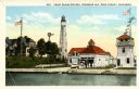
| Date: | 1900 |
|---|---|
| Description: | View of the coast guard station from the water with multiple sailors lined up near the shore. Caption reads: "Coast Guard Station, Sturgeon Bay, Door Count... |
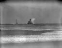
| Date: | |
|---|---|
| Description: | A large wave is breaking against the side of the Milwaukee breakwater lighthouse. There is a ship on the left, in the distance beyond the jetty. |

| Date: | |
|---|---|
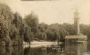
| Description: | View of the lake front at Lakeside Park, with a lighthouse and docked boats. Caption reads: "Light House and Harbor, Lakeside Park, Fond du Lac, Wis." |

| Date: | 1970 |
|---|---|
| Description: | A Blue Heron is standing on a breakwater in Lake Michigan. The Sheboygan Breakwater Lighthouse is on the horizon. |

| Date: | 1907 |
|---|---|
| Description: | Text on front reads: "Ice Scene on the Pier, Sheboygan, Wis." Ice streamers hang from a pier leading to a lighthouse on Lake Michigan's shore. |

| Date: | 07 04 1931 |
|---|---|
| Description: | Inside of Saturday dinner menu for the "North American." Includes drawings of Niagara Falls, New York, Old Fort Mackinac Island, Michigan, Michigan Bouleva... |
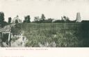
| Date: | 1910 |
|---|---|
| Description: | Caption reads: "Old Light House at Long Tail Point, Green Bay, Wis." Built in 1859. A marshy area is in the foreground, and a long pier leads to the new li... |

| Date: | 01 06 1958 |
|---|---|
| Description: | View from jetty out towards Lake Michigan entrance to Ship Canal. A large tank, streetlamp and buildings are on the left. On the opposite jetty is a lighth... |

| Date: | 07 19 1854 |
|---|---|
| Description: | This map shows the shore in 1844, 1850, and 1852, the length of and proposed additions to the pier. Relief is shown by hachures and depths are shown by sou... |

| Date: | 1970 |
|---|---|
| Description: | This map shows roads, parks, swimming beaches, golf courses, yacht harbors, light houses, airports, public hunting grounds, waysides, schools, and fishing ... |
If you didn't find the material you searched for, our Library Reference Staff can help.
Call our reference desk at 608-264-6535 or email us at: