 Search: LIGHTHOUSES
Filter: Subject of apostle islands
Search: LIGHTHOUSES
Filter: Subject of apostle islands

| Date: | |
|---|---|
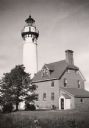
| Description: | Michigan Island Lighthouse, Apostle Islands, Lake Superior. |
| Date: | |
|---|---|
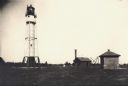
| Description: | Lighthouse and buildings on Devil's Island of the Apostle Islands. |
| Date: | 1950 |
|---|---|
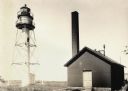
| Description: | Lighthouse on Outer Island of the Apostle Islands. |
| Date: | |
|---|---|
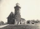
| Description: | La Pointe Light on Long Island (Apostle Islands), Chequamegon Bay, Lake Superior. |
| Date: | 1915 |
|---|---|
| Description: | Sand Island Lighthouse on Apostle Island, Lake Superior. Lighthouse keeper and family are posing in the front of the building. |

| Date: | 1871 |
|---|---|
| Description: | This map shows railroads, canals, towns and some lighthouses. Areas of the company lands proper, tin, iron, gold & silver, silver islet, and lead are color... |
| Date: | 1934 |
|---|---|
| Description: | View from water of Devil's Island lighthouse located above sandstone caves and arches in the Apostle Islands of Lake Superior. Caption reads: "Devil's Isla... |

| Date: | 1908 |
|---|---|
| Description: | A detailed map of Michigan Island and Gull Island in the Apostle Islands group (T51N, R1W, 4 M) that shows sections, landowners, the Michigan Island Lighth... |
If you didn't find the material you searched for, our Library Reference Staff can help.
Call our reference desk at 608-264-6535 or email us at: