 Search: Bureau
Search: of
Filter: Categories of Wisconsin Historical Images
Filter: Year of 1800-1899
Filter: Year of 1890-1899
Search: Bureau
Search: of
Filter: Categories of Wisconsin Historical Images
Filter: Year of 1800-1899
Filter: Year of 1890-1899

| Date: | 1899 |
|---|---|
| Description: | This color map, originally published in the Smithsonian Institution Bureau of American Ethnology's 18th annual report, shows the Indian land cessions in Wi... |

| Date: | 1899 |
|---|---|
| Description: | This map shows color coded and numbered regions of Indian land cessions. Lake Superior and Lake Michigan are labeled and other lakes and rivers are shown. ... |

| Date: | 1899 |
|---|---|
| Description: | This map shows color coded and numbered regions of Indian land cessions. Lake Superior and Lake Michigan are labeled and other lakes and rivers are shown. ... |

| Date: | 1897 |
|---|---|
| Description: | A map of Wisconsin showing the self-supporting churches, Home Missionary churches, stations not organized, Sunday schools of C.S.S. Society, Congregational... |
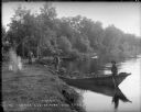
| Date: | 1899 |
|---|---|
| Description: | View along shoreline towards Indian log drivers, two in a bateau, and one man standing on the bank of the Chippewa River. |
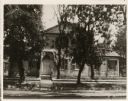
| Date: | 1890 |
|---|---|
| Description: | View of a house in a residential area, obscured by trees. "The house was built in 1835 by Ellis and was last occupied by the Misses Bessie and Barbara Hage... |
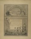
| Date: | 1893 |
|---|---|
| Description: | Award certificate presented to the Appleton Woolen Mills at the 1893 Chicago World's Fair. The company won a bronze medal at the Fair for its paper makers... |

| Date: | 1899 |
|---|---|
| Description: | Two men smiling and shake hands outdoors. The man on the right is wearing a military uniform, and the man on the left is holding a rifle. There is a buildi... |
If you didn't find the material you searched for, our Library Reference Staff can help.
Call our reference desk at 608-264-6535 or email us at: