 Search: Bureau
Search: of
Filter: Categories of Wisconsin Historical Images
Filter: Subject of indians of north america
Search: Bureau
Search: of
Filter: Categories of Wisconsin Historical Images
Filter: Subject of indians of north america

| Date: | 1899 |
|---|---|
| Description: | This color map, originally published in the Smithsonian Institution Bureau of American Ethnology's 18th annual report, shows the Indian land cessions in Wi... |
| Date: | |
|---|---|
| Description: | An Ojibwa herbalist prepares medicine and treats a patient. From the "Annual Report of the Bureau of Ethnology J.W. Powell Director 1885-1886" page 159. |

| Date: | 1835 |
|---|---|
| Description: | Constructed for the Topographical Bureau [Wash.], 1835. Scale: 16 miles to 1 inch. Map of a portion of the Indian country lying east and west of the Missis... |

| Date: | 1939 |
|---|---|
| Description: | This nine-part map from the U.S. Bureau of Public Roads identifies federal and state highways in Wisconsin by pavement type. County, forest, park, and publ... |

| Date: | 1941 |
|---|---|
| Description: | Wisconsin counties, towns, cities, and selected villages, as well as the Menominee Indian Reservation are identified on this U.S. Bureau of the Census map ... |

| Date: | |
|---|---|
| Description: | Menominee Indian "garters" made of beads and yarn. |
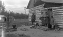
| Date: | |
|---|---|
| Description: | Winter view of Chippewa (Ojibwa) Valley village. |
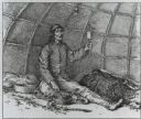
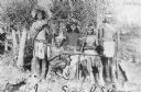
| Date: | |
|---|---|
| Description: | Medicine man John King, his wife, grandchild, and family on the Lake Courte Oreilles Chippewa reservation near Couderay. |

| Date: | 1899 |
|---|---|
| Description: | This map shows color coded and numbered regions of Indian land cessions. Lake Superior and Lake Michigan are labeled and other lakes and rivers are shown. ... |
| Date: | 1874 |
|---|---|
| Description: | Copy photograph of a painting of a Sioux Sun Dance ritual. Painting by Jules Tavernier. |

| Date: | 1857 |
|---|---|
| Description: | Information depicting the history, condition and prospects of the Indian tribes of the United States: collected and prepared under the direction of the Bur... |
| Date: | |
|---|---|
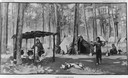
| Description: | Illustration of an Indian (possibly Menominee) camp of sugar makers. |

| Date: | 1899 |
|---|---|
| Description: | This map shows color coded and numbered regions of Indian land cessions. Lake Superior and Lake Michigan are labeled and other lakes and rivers are shown. ... |
| Date: | |
|---|---|
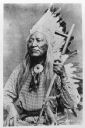
| Description: | Photograph of a portrait of Shoshone leader Chief Washakie, who is holding a pipe. Caption indicates it is "from a woodcut." |

| Date: | 1944 |
|---|---|
| Description: | This nine-part map from the U.S. Bureau of Public Roads identifies federal and state highways in Wisconsin by pavement type. County, forest, park, and publ... |
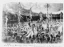
| Date: | 1900 |
|---|---|
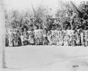
| Description: | A group of men posing together in front of a stand of trees. Caption reads: "Indian 'Sun Dance' near Fort Washakie, Wyo, 1900." |

| Date: | |
|---|---|
| Description: | Photograph of an oil painting of Hunkpapa Lakota leader Sitting Bull, depicted standing and holding a rifle. Caption reads: "Oil painting of Sitting Bull b... |

| Date: | 1835 |
|---|---|
| Description: | Little Lake Butte Des Morts just north of Lake Winnebago where Governor Lewis Cass of Michigan, and Thomas McKenney, head of the Bureau of Indian Affairs (... |
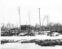
| Date: | 1899 |
|---|---|
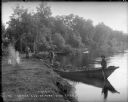
| Description: | View along shoreline towards Indian log drivers, two in a bateau, and one man standing on the bank of the Chippewa River. |
| Date: | |
|---|---|
| Description: | Copy photograph of several young men posing with rifles. Caption reads: "Apache Indian scouts on duty with the 6th Cavalry at Fort Wingate. New Mexico." |
If you didn't find the material you searched for, our Library Reference Staff can help.
Call our reference desk at 608-264-6535 or email us at: