Search: Bureau
Search: of
Filter: Categories of Wisconsin Historical Images
Filter: County of Brown
Search: Bureau
Search: of
Filter: Categories of Wisconsin Historical Images
Filter: County of Brown
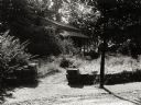
| Date: | 07 1929 |
|---|---|
| Description: | View of the front path leading to the cottage. |
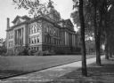
| Date: | 1929 |
|---|---|
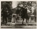
| Description: | Exterior of Brown County Court House, with trees lining the sidewalk. |
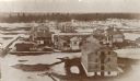
| Date: | 1865 |
|---|---|
| Description: | Elevated view of the fort, with snow on the ground. |

| Date: | |
|---|---|
| Description: | Mothers and infant children stand in front of the Brown County Trailer. |
| Date: | |
|---|---|
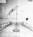
| Description: | View of the parade grounds surrounded by possibly the barracks. An American flag on a pole dominates the image. |
| Date: | 1870 |
|---|---|
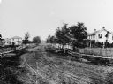
| Description: | View of dirt road with houses along both sides, and wooden walkways and picket fences along the road. |

| Date: | 1816 |
|---|---|
| Description: | This is a photostat copy of a manuscript map in the National Archives showing a plan of Fort Howard and a view of its north side. Originally surveyed by Wi... |
| Date: | 1930 |
|---|---|
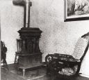
| Description: | Interior of the cottage with a rocking chair, a wood stove, a painting on the wall, and a spinning wheel on the left. The floor is wooden, and the wallpape... |
| Date: | 1890 |
|---|---|
| Description: | View of a house in a residential area, obscured by trees. "The house was built in 1835 by Ellis and was last occupied by the Misses Bessie and Barbara Hage... |

| Date: | 1935 |
|---|---|
| Description: | Colorized postcard view of a fraternal lodge building. Automobiles are parked along the curbs. Caption reads: "Columbus Community Club Building, Green Bay,... |
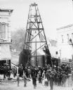
| Date: | 1885 |
|---|---|
| Description: | Elevated view of a crowd of people standing near an artesian well. Men wearing long coats and hats to protect them from the water are standing on and unde... |

| Date: | 1818 |
|---|---|
| Description: | Overhead view of the layout of the fort, with the Fox River at the top, and a "Cranberry Marsh of 1/2 mile in extent" below right. At the bottom is a rende... |

| Date: | 1862 |
|---|---|
| Description: | This map shows landownership on a military reserve, private claims, buildings (including Fort Howard and U.S. sawmill), swamps, public barns and fields, an... |

| Date: | 1875 |
|---|---|
| Description: | Elevated view of several buildings, with bridge and railroad tracks, and the Fox River. In the foreground on the right is the Commercial House, with three ... |

| Date: | 1870 |
|---|---|
| Description: | Elevated view of an unpaved main street, with the Village House across the street in the center background. Wooden buildings and wooden sidewalks are on bo... |
If you didn't find the material you searched for, our Library Reference Staff can help.
Call our reference desk at 608-264-6535 or email us at: