 Search: A.
Search: Lapham
Search: papers
Filter: Categories of Wisconsin Historical Images
Search: A.
Search: Lapham
Search: papers
Filter: Categories of Wisconsin Historical Images

| Date: | 12 22 1830 |
|---|---|
| Description: | Increase Lapham's drawing of the geological profile between the Sandusky plains and Portsmouth, Ohio. |
| Date: | 1854 |
|---|---|
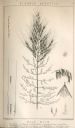
| Description: | Increase Lapham's drawing of Zizania aquatica. The plant's common name is Northern Wild Rice. |
| Date: | 1838 |
|---|---|
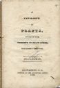
| Description: | Title page of Increase Lapham's Catalog of Plants Found in the vicinity of Milwaukee, Wisconsin Territory. |

| Date: | 1849 |
|---|---|
| Description: | Pencil sketch of a cross-section of the Dells of the Wisconsin River. People are in a row boat in the center. Caption at bottom: "The Dells — Wisconsin Riv... |
| Date: | 1828 |
|---|---|
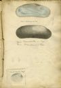
| Description: | Increase Lapham's drawing of a Union mondonta (or Unio soleniformis) shell. There are also two views of another shell drawn below and a drawi... |
| Date: | |
|---|---|
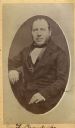
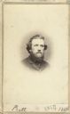
| Description: | Carte-de-visite portrait of Franz Brandecke, Milwaukee-based geologist. Worked on Wisconsin geological survey with Lapham. Handwritten text on front read... |

| Date: | |
|---|---|
| Description: | Letterhead stationery featuring an engraving of the Milwaukee Iron Company foundry. The letter is from an officer of the company to noted geologist Increas... |
| Date: | 1827 |
|---|---|
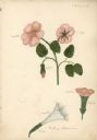
| Description: | Drawings of Datura Stramonium, more commonly known by the names jimson weed, devil's trumpet, devil's weed, thorn apple, tolguacha, Jamestown weed, stinkwe... |
| Date: | 1865 |
|---|---|
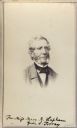
| Description: | Vignetted carte-de-visite quarter-length portrait of John Torrey (1796-1863), American botanist. Worked as New York state botanist from 1836. Handwritten i... |
| Date: | 1845 |
|---|---|
| Description: | Page from Increase Lapham's 1845 list of plants of Wisconsin including Oxalidaceae, Zanthoxylaceae, and Anacardiaceae and notations of where and when indiv... |

| Date: | 1833 |
|---|---|
| Description: | Increase Lapham's plan for the canal terminus on Portsmouth Point at the confluence of the Scioto and Ohio Rivers. |

| Date: | 1828 |
|---|---|
| Description: | Increase Lapham's drawing and description of an earth borer for his handwritten manuscript, Notes and Accounts of Canals, Particularly the Ohio Canal Ne... |
| Date: | 1865 |
|---|---|
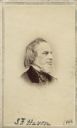
| Description: | Vignetted carte-de-visite portrait of Samuel Foster Haven (1806-1881), Massachusetts anthropologist, librarian, and archaeologist. Haven is best known as t... |
| Date: | |
|---|---|
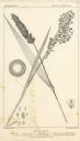
| Description: | Increase Lapham's drawing of Setaris Italica or foxtail millet and Panicum miliaceum or proso millet. There are also inset drawings of a spik... |

| Date: | 1864 |
|---|---|
| Description: | This map is pen and watercolor on paper and shows a profile and geological sections of the Apple River, Little Otter Creek, Woods' Branch, Bonners' Branch,... |
| Date: | |
|---|---|
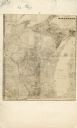
| Description: | Carte-de-visite map of Wisconsin. Broken down into a grid, and includes some topography and Lake Michigan. The letters "M.C." have been written on top of t... |
| Date: | 1864 |
|---|---|
| Description: | Vignetted carte-de-visite portrait of William H. Pratt of Davenport, Iowa. Handwritten inscription at bottom reads, "Pratt, 1864." |
| Date: | 12 1860 |
|---|---|
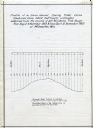
| Description: | Graph showing the profile of a semi-diurnal spring tidal curve deduced from 5452 half hourly ordinates obtained from the records of self registering tide g... |

| Date: | 1864 |
|---|---|
| Description: | This map is pen and watercolor on paper and shows a profile and geological sections of the Blue Mounds, Hollow Run, Bogies Hollow Run, Bear Creek, East Bre... |

| Date: | 1864 |
|---|---|
| Description: | This map is pen and watercolor on paper and shows a profile and geological sections of the Spensley Break, James Break, Wisconsin River, and Little Bear Cr... |
If you didn't find the material you searched for, our Library Reference Staff can help.
Call our reference desk at 608-264-6535 or email us at: