 Filter: Year of 1900-1999
Filter: County of Sheboygan
Filter: Year of 1900-1999
Filter: County of Sheboygan

| Date: | 1921 |
|---|---|
| Description: | Three men sitting on the ground next to a horse-drawn wagon are having lunch. Two of them have jugs; one is holding a cup. All three are wearing work cloth... |
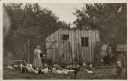
| Date: | 1900 |
|---|---|
| Description: | An unidentified woman standing near a shed is feeding chickens and geese in the barnyard. |

| Date: | 1900 |
|---|---|
| Description: | Two young women and a girl stand in a pasture with a cow and a calf. One of the women is holding a pail; the other a sprig of flowers. |

| Date: | 1900 |
|---|---|
| Description: | A young woman dressed as a maid in a long apron and wearing a mob cap, stands outdoors against the side of a house. She has a set of keys hanging from her ... |

| Date: | 1909 |
|---|---|
| Description: | Two women sit pensively on stone benches on either side of a muddy gravel path. The one on the left is Elsie. Near her in the background are four children.... |

| Date: | 1914 |
|---|---|
| Description: | Anna Fiebelkorn is in the back seat of the car with another woman and two toddlers. William Fiebelkorn is driving the touring car. A small boy is sitting i... |
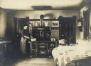
| Date: | 1905 |
|---|---|
| Description: | A woman is stirring a pot on what looks like a new stove. It is a gleaming Acme, from Newark Stove Works. There is a warming closet in the top half. The ca... |

| Date: | 1956 |
|---|---|
| Description: | This maps shows voting precincts and polling places as well as wards. Streets and the Sheboygan River are labeled. The bottom right of the map features a l... |

| Date: | 1989 |
|---|---|
| Description: | This pictorial map shows the Sheboygan river, businesses with phone numbers, historical buildings, other places of interest, and includes a brief history o... |

| Date: | 1921 |
|---|---|
| Description: | This map shows Lake Michigan, the Sheboygan River, buildings, streets, churches, industrial yards, and parks. Relief is shown by hachures and depths are sh... |

| Date: | 1915 |
|---|---|
| Description: | This map shows wards, railroads, street railways, streets, lot and block numbers, parks, and hospitals. Also included are manuscript annotations of points ... |

| Date: | 1936 |
|---|---|
| Description: | Winter scene with man driving a Model RD-8 La Plant-Choate V-Plow Snow Plow with side extension blades from the front. In the background are power poles. |

| Date: | 1959 |
|---|---|
| Description: | This map shows some land ownership, lot and block numbers, additions, fair grounds, streets, and railroads and is indexed. Mullet River and Mill Pond are l... |

| Date: | 1961 |
|---|---|
| Description: | This map shows wards as well as proposed future streets, lot and block numbers, additions, and some landownership. The Sheboygan River is labeled. |

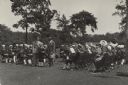
| Date: | 06 02 1930 |
|---|---|
| Description: | Governor Walter J. Kohler Sr. stands for a group portrait with several men and women on a lawn with trees and foliage. He is the fifth person from the righ... |
| Date: | 07 02 1930 |
|---|---|
| Description: | Governor Walter Kohler Sr. shakes the hand of a young boy, Henry Stoehr. They stand next to Henry Winsauer, and are surrounded by members of the Kohler Jun... |

| Date: | 07 02 1930 |
|---|---|
| Description: | Group portrait of four men standing outdoors under the wing of an airplane. From left to right: F.S. Brandenburg, Governor Kohler, George Charlesworth, and... |
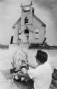
| Date: | 09 06 1968 |
|---|---|
| Description: | View of the front wall left standing of the Trinity Lutheran Church. A man in the foreground us painting a portrait of the church. The artist is identified... |

| Date: | 1926 |
|---|---|
| Description: | This blueprint map shows the Sheboygan River, buildings, and roads in the vicinity of the harbor. The map has explanations including "dredging required to ... |

| Date: | 1926 |
|---|---|
| Description: | This map includes a legend in the lower right corner of building heights. Districts marked "A" are 35 foot, districts marked "B" are 45 foot, districts mar... |
If you didn't find the material you searched for, our Library Reference Staff can help.
Call our reference desk at 608-264-6535 or email us at: