 Filter: Year of 1700-1799
Filter: Year of 1770-1779
Filter: Year of 1700-1799
Filter: Year of 1770-1779
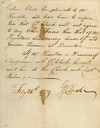
| Date: | 02 24 1779 |
|---|---|
| Description: | Letter from Colonel George Rogers Clark to Lieutenant Governor Henry Hamilton demanding unconditional surrender of Fort Vincennes. |

| Date: | 1776 |
|---|---|
| Description: | In French: "Partie Occidentale du Canada et septentrionale de la Louisiane avec une partie de la Pensilvanie." A map showing graticule and six European sca... |
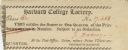
| Date: | 1774 |
|---|---|
| Description: | Ticket for the Harvard College Lottery. |

| Date: | 1772 |
|---|---|
| Description: | Scale: about 180 miles to 1 in. |

| Date: | 07 04 1776 |
|---|---|
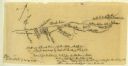
| Description: | Hand-drawn map of the area where the Battle of Black's Fort took place. |
| Date: | 07 04 1776 |
|---|---|
| Description: | Notes written in red ink on the back of the map of the Battle of Black's Fort. |
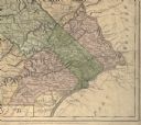
| Date: | 1775 |
|---|---|
| Description: | Detail of Pennsylvania map showing Chester, Philadelphia, and Bucks counties. |

| Date: | 07 1774 |
|---|---|
| Description: | Front page of a letter written and signed by Dan Smith. |

| Date: | 07 1774 |
|---|---|
| Description: | Back page of a letter written and signed by Dan Smith. |
| Date: | 1777 |
|---|---|
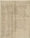
| Description: | A pay roll, handwritten by Captain Joseph Martin, listing men under the command of Major Bledsoe at Rye Cove on Clinck. |
| Date: | 1777 |
|---|---|
| Description: | A pay roll handwritten by Captain Joseph Martin listing men stationed on the Frontiers of Washington County under the command of Colonel Evan Shelby. |
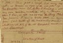
| Date: | 1777 |
|---|---|
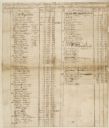
| Description: | The back side of Captin Joseph Martin's pay roll from 1 May through 30 June, 1777. There are columns of numbers beneath the writing. |

| Date: | 1778 |
|---|---|
| Description: | Hand-colored. London, 1778. Coordinates: W 99⁰--W 83⁰/N 49⁰--N 41⁰. Scale [ca. 1:3,500,000] |
| Date: | 07 08 1774 |
|---|---|
| Description: | A hand-drawn map showing forts along the Clinch River. |
| Date: | 08 17 1778 |
|---|---|
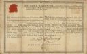
| Description: | Document supporting the presentation of a medal presented by Frederick Haldimand, Captain-General and Governor in Chief of the Province of Quebec to Menomi... |

| Date: | 1778 |
|---|---|
| Description: | This Italian map from 1778 depicts the upper portion of the Old Northwest. Rivers and lakes are identified and relief, real and imagined, is depicted picto... |
| Date: | 07 13 1778 |
|---|---|
| Description: | A brief letter written by Daniel Boone to "Dear Col." |
| Date: | 08 11 1774 |
|---|---|
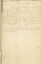
| Description: | A letter from James Robertson to Col. William Preston. From Preston and Virginia Papers [Calendar series Volume 1]: "Culbertson's. Letter to Col. Wi... |

| Date: | 10 12 1774 |
|---|---|
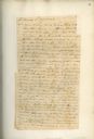
| Description: | A repaired letter written by Maj. Arthur Campbell to William Preston. From Preston and Virginia Papers [Calendar series Volume 1]: "Royal Oak. Lette... |

| Date: | 10 12 1774 |
|---|---|
| Description: | The back page of a repaired letter from Maj. Arthur Campbell to William Preston. From Preston and Virginia Papers [Calendar series Volume 1]: "Royal... |
If you didn't find the material you searched for, our Library Reference Staff can help.
Call our reference desk at 608-264-6535 or email us at: