 Filter: Year of 1700-1799
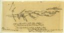
| Date: | 07 04 1776 |
|---|---|
| Description: | Notes written in red ink on the back of the map of the Battle of Black's Fort. |

| Date: | 1784 |
|---|---|
| Description: | Map of The United States of America according to the Treaty of Peace of 1784. |

| Date: | 1766 |
|---|---|
| Description: | Portrait of Mohegan minister and preacher Samson Occom, posed sitting with his finger on a Bible on a bookstand, with Indian implements visible on the wall... |
| Date: | 1775 |
|---|---|
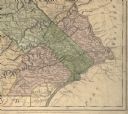
| Description: | Detail of Pennsylvania map showing Chester, Philadelphia, and Bucks counties. |

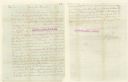
| Date: | 07 1774 |
|---|---|
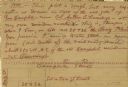
| Description: | Front page of a letter written and signed by Dan Smith. |

| Date: | 07 1774 |
|---|---|
| Description: | Back page of a letter written and signed by Dan Smith. |
| Date: | 1777 |
|---|---|
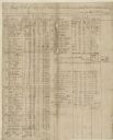
| Description: | A pay roll, handwritten by Captain Joseph Martin, listing men under the command of Major Bledsoe at Rye Cove on Clinck. |
| Date: | 1777 |
|---|---|
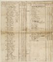
| Description: | A pay roll handwritten by Captain Joseph Martin listing men stationed on the Frontiers of Washington County under the command of Colonel Evan Shelby. |
| Date: | 1777 |
|---|---|
| Description: | The back side of Captin Joseph Martin's pay roll from 1 May through 30 June, 1777. There are columns of numbers beneath the writing. |

| Date: | 1744 |
|---|---|
| Description: | Paris: 1744. W 92⁰--W 76⁰/N 49⁰--N 41⁰. Scale [ca. 1:4,000,000] |

| Date: | 1778 |
|---|---|
| Description: | Hand-colored. London, 1778. Coordinates: W 99⁰--W 83⁰/N 49⁰--N 41⁰. Scale [ca. 1:3,500,000] |

| Date: | 1755 |
|---|---|
| Description: | Hand-colored. Paris: 1755. Scale [ca. 1:3,000,000]. |

| Date: | 1757 |
|---|---|
| Description: | The Canadian Lakes. Scale [ca. 1:6,500,000]. Paris: 1757. |
| Date: | 1745 |
|---|---|
| Description: | A two page world map featuring the Eastern and Western Hemispheres, as well as the northern and southern zodiacs. Additionally, the map is ordained with n... |

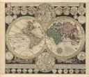
| Date: | 1745 |
|---|---|
| Description: | A two page illustration featuring a small globe in the center of numerous astrological spheres. Additionally, the representation features writing, in Lati... |
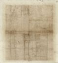
| Date: | 07 08 1774 |
|---|---|
| Description: | A hand-drawn map showing forts along the Clinch River. |
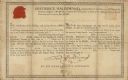
| Date: | 08 17 1778 |
|---|---|
| Description: | Document supporting the presentation of a medal presented by Frederick Haldimand, Captain-General and Governor in Chief of the Province of Quebec to Menomi... |
| Date: | 1783 |
|---|---|
| Description: | Letter from Thomas Jefferson to George Rogers Clark suggesting a transcontinental expedition. |

| Date: | 1778 |
|---|---|
| Description: | This Italian map from 1778 depicts the upper portion of the Old Northwest. Rivers and lakes are identified and relief, real and imagined, is depicted picto... |

| Date: | 1792 |
|---|---|
| Description: | Map of Washington D.C. Labeled on the map are all the main streets, the site of the Capitol and the President's House. The map also shows the relationship ... |
If you didn't find the material you searched for, our Library Reference Staff can help.
Call our reference desk at 608-264-6535 or email us at: