 Filter: Subject of botany
Filter: Type of Map or Atlas
Filter: County of Dane
Filter: Subject of botany
Filter: Type of Map or Atlas
Filter: County of Dane

| Date: | 1876 |
|---|---|
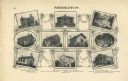
| Description: | Bird's-eye view of Middleton with an inset of a school house. |

| Date: | 1875 |
|---|---|
| Description: | Bird's-eye map of Mazomanie. |

| Date: | 1927 |
|---|---|
| Description: | Blueprint-style map of Frost Woods on the shore of Lake Monona. The map indicates the locations of Indian mounds, an Indian camp, and various plants. There... |

| Date: | 1948 |
|---|---|
| Description: | This 1948 map shows contour and spot depths in Lake Wingra in Madison, Wisconsin. The shore outline is based on a 1940 aerial photograph. |
| Date: | 1911 |
|---|---|
| Description: | "Standard Historical Atlas of Dane County, Wisconsin." Top half of page 98, showing all of the different district schools in Middleton. |
| Date: | 05 1938 |
|---|---|
| Description: | Map of the University of Wisconsin-Madison arboretum and wild life refuge. Roads are labelled, left to right: "Nakoma Road," "Monroe St.," "Manitou Way," "... |

| Date: | 1970 |
|---|---|
| Description: | Color coded map. Legend in the top left hand corner reads: "EXISTING AIRPORT PAVEMENT" (purple), "FUTURE 5-YEAR DEVELOPMENT" (bright pink), "ULTIMATE AIRPO... |

| Date: | 1970 |
|---|---|
| Description: | Map features a legend of roads, trails, points of interest, buildings, and types of vegetation. To the right are "ARBORETUM REGULATIONS" regarding hours, p... |

| Date: | 1880 |
|---|---|
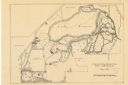
| Description: | This map is pen-and-ink on paper. The map shows buildings, trees, and water and gas pipes, relief is shown by contours. The back of the map reads: "Univers... |
| Date: | 1920 |
|---|---|
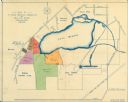
| Description: | This map shows an arboretum and wildlife refuge in Madison, Wisconsin. There are color coded parcels "F" through "K" with acreages, as well as area around ... |

| Date: | 1855 |
|---|---|
| Description: | This bird's-eye-view map of Madison is looking north across Lake Monona. The map features two women and two men on a lookout on top of a building in the fo... |

| Date: | 1932 |
|---|---|
| Description: | This map shows local streets, section lines, Nakoma Country Club, part of Lake Forest, and part of Lake Wingra. The map includes a legend showing areas of ... |

| Date: | 04 1905 |
|---|---|
| Description: | Map of the Madison, Wisconsin region showing the four major lakes, starting in the north with Lake Mendota, Lake Monona, Lake Waubesa, and Lake Kegonsa. La... |

| Date: | 1924 |
|---|---|
| Description: | This pictorial map focuses on the Madison Isthmus, Lake Mendota, Lake Monona, Lake Wingra, and shows points of historical interest, buildings, parks, and I... |

| Date: | 1933 |
|---|---|
| Description: | Blue print and blue line print maps that show local streets, Nakoma Country Club, part of Lake Forest, and part of Lake Wingra. A legend is included that s... |

| Date: | 10 1911 |
|---|---|
| Description: | This map shows lot numbers, building lines, roads, trees, and Indian mounds. Relief is shown by contours. Includes manuscript annotations marking parks. |

| Date: | 1920 |
|---|---|
| Description: | This map, with north oriented to the right, shows a plat of the area, numbered blocks and lots, local streets, roads, parks, a proposed golf course, and la... |
If you didn't find the material you searched for, our Library Reference Staff can help.
Call our reference desk at 608-264-6535 or email us at:

