 Filter: Subject of Surveying

| Date: | 07 07 1915 |
|---|---|
| Description: | Ink on tracing cloth. Includes signed certifications from the surveyor, notary public, and Wisconsin Realty Company. From the E.P. Sherry papers relating t... |

| Date: | 1921 |
|---|---|
| Description: | Relief shown by contours and spot heights. Includes inset location map. "Contour interval 10 feet." "Advance sheet, subject to correction." "Surveyed in 19... |
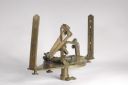
| Date: | |
|---|---|
| Description: | A brass solar compass, invented by William Austin Burt and built by William J. Young. It was used to survey lands in Wisconsin and surrounding areas during... |

| Date: | 07 14 1958 |
|---|---|
| Description: | This is a Tellurometer, a microwave surveying instrument. The operator is Don Reed, field man for Alster and Associates, Washington, D.C., which completed ... |

| Land Speculator and Politician |
|---|
| Brief biography of surveyor, land speculator, railroad promoter and politician Byron Kilbourn, twice elected mayor of Milwaukee. |
| Discover historical details and explore our online collections related to West Bend, Wisconsin. |
| Wisconsin Historical Museum Object – Feature Story |
|---|
| Surveyor's tree blaze from the 1841 expedition to lay out the boundary between Wisconsin and Michigan, found at Trout Lake, Vilas County, Wisconsin. (Museu |
| Wisconsin Historical Museum Object – Feature Story |
|---|
| Solar Compass used to survey lands in Wisconsin and surrounding areas during the 1840s and 1850s. (Museum object #1962.60.2,A) |
| Learn about the first official government survey of Wisconsin Territory |
| Speculating on a Dream |
|---|
| Join cantankerous British geologist George Featherstonehaugh as he travels to Madison in 1837 and finds things not as he expected them to be. |
| Learn about the creation of Wisconsin's first maps, with links to the surveyors' notebooks and diaries and the state's first township maps. |
| How Wisconsin was Divided |
|---|
| Discover how the Ordinance of 1787 extended government, prohibited slavery and led to the survey of public lands north of the Ohio River. |

| Date: | 1873 |
|---|---|
| Description: | This map shows lots and blocks, additions and subdivisions, and large-scale landownership. The map is oriented with north to the upper right. The map is fr... |
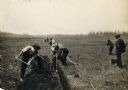
| Date: | |
|---|---|
| Description: | View of a crew surveying land, digging a ditch, and laying drain tile. |
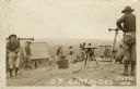
| Date: | |
|---|---|
| Description: | Photographic postcard view of a group of surveyors working on a hilltop at Camp McCoy. Caption reads: "O. P. Camp McCoy, Sparta, Wis." |
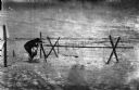
| Date: | 1918 |
|---|---|
| Description: | Outdoor view of a U.S. Army Engineer topographer wearing skis while in the process of surveying land. The engineer is standing next to a barbed wire obstac... |

| Date: | 1918 |
|---|---|
| Description: | Outdoor view of a U.S. Army Engineer topographer wearing skis while using a tripod stand to write. The engineer is standing next to a barbed wire obstacle ... |
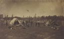
| Date: | 07 01 1871 |
|---|---|
| Description: | Railroad surveying party in camp somewhere north of Green Bay. The men were surveyors for the Chicago & Northwestern railroad extension. |

| Date: | 09 20 1836 |
|---|---|
| Description: | This map is ink and watercolor on paper and is an unnamed plat. Green Bay is labeled and the plat is labeled "Section 22." One road is labeled "Road to Nav... |

| Date: | 02 02 1960 |
|---|---|
| Description: | The Madison Redevelopment Authority joined in the city's program of locating and permanently marking land survey corners in the Madison area. Here they mar... |
If you didn't find the material you searched for, our Library Reference Staff can help.
Call our reference desk at 608-264-6535 or email us at: