 Filter: Subject of Streetcars

| Date: | 1901 |
|---|---|
| Description: | This map shows public schools, engine houses, railroads, street railways, city wards, parks, block numbers, and Lake Michigan. Also included are indexes, t... |

| Date: | 1904 |
|---|---|
| Description: | This map has three inset maps of Whitefish Bay, Cudahy, and South Milwaukee. This map depicts schools, engine houses, railroads, street railways, city ward... |

| Date: | 1904 |
|---|---|
| Description: | This map shows wards, schools, engine houses, railroads, street railways, block numbers, parks, roads, and Lake Michigan. Also included are indexes: Table ... |

| Date: | 1907 |
|---|---|
| Description: | This map shows ward numbers, streets, railroads, electric car lines, parks, steam railways, section numbers, Lake Michigan and one mile concentric circles ... |

| Date: | 1911 |
|---|---|
| Description: | This map shows ward numbers, streets, railroads, electric car lines, parks, steam railways, section numbers, Lake Michigan and one mile concentric circles ... |

| Date: | 1912 |
|---|---|
| Description: | This map shows ward numbers, streets, railroads, electric car lines, parks, steam railways, section numbers, Lake Michigan and one mile concentric circles ... |

| Date: | 1916 |
|---|---|
| Description: | This map shows ward numbers, streets, railroads, electric car lines, parks, steam railways, section numbers, rivers, Lake Michigan, churches, schools, and ... |

| Date: | 1910 |
|---|---|
| Description: | This ink on paper blue line print base map consists of eight separate pieces and shows city limits, The Milwaukee Electric Railroad & Light Company lines, ... |

| Date: | 1927 |
|---|---|
| Description: | This map shows highways, roads, a proposed annexation, street car lines, bus routes, local motor bus lines, a new high speed interurban, railroads, a propo... |

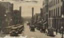
| Date: | 1914 |
|---|---|
| Description: | Seventh Street looking east. Streetcars are running in both diretions, and horse-drawn vehicles and bicycles are near the curb. The sidewalks are filled wi... |

| Date: | 03 1929 |
|---|---|
| Description: | View from street towards the H.H. Ratcliff Company, jewelers and opticians, at 29 S. Pinckney Street. Across the street, the building on the corner of Main... |

| Date: | 1927 |
|---|---|
| Description: | View from street towards the corner of King Street and S. Pinckney Street. On the corner is the Haw-Olson Company. Down King Street is the Majestic Theater... |

| Date: | |
|---|---|
| Description: | View across intersection towards the First National Bank at the corner of East Washington Avenue and South Pinckney Streets. |

| Date: | 01 13 1914 |
|---|---|
| Description: | Smoke billowing from windows on the State Street (left) and Carroll Street (right) sides of the Wisconsin Building. Fire fighters on ladders are working fr... |
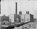
| Date: | 1900 |
|---|---|
| Description: | Elevated view of McCormick Works, with construction of wheel shop. Streetcars are along the street in the foreground. |

| Date: | |
|---|---|
| Description: | Six circular images on a glass plate negative from the Stirn Concealed Vest Camera. One of the images is of a black dog standing on its hind legs; another ... |

| Date: | |
|---|---|
| Description: | View up center of King Street towards the third Wisconsin State Capitol. There are streetcar tracks, and large power poles are along the left side of the s... |
| Date: | 05 1930 |
|---|---|
| Description: | View of heavy automobile traffic, delivery trucks and pedestrians on State Street, seen looking west from the 200 block. In the background is Bascom Hill, ... |

| Date: | |
|---|---|
| Description: | View of Sid sitting in his backyard on the back of his trolley car, "Toonerville," holding a stick in his hand and pretending to fish. Sid is wearing a lar... |

| Date: | |
|---|---|
| Description: | View through a City Hall archway of the city square, which includes a statue, a streetcar, and a decorative lamp post. Caption reads: "City Hall Square, Mi... |
If you didn't find the material you searched for, our Library Reference Staff can help.
Call our reference desk at 608-264-6535 or email us at: