 Filter: Subject of Shipping
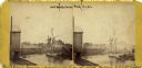
| Date: | 1870 |
|---|---|
| Description: | View of a lumber hooker ship at dock on the Root River. The 4th St. bridge spans the river at center. The Racine Woolen Mill is visible at right behind the... |
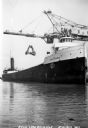
| Date: | 1930 |
|---|---|
| Description: | View of the ship "Alex B. Uhrig" in the process of coal unloading on the Reiss Coal Dock No. 2. |
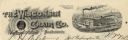
| Date: | |
|---|---|
| Description: | Memohead of the Wisconsin Chair Company of Port Washington, Wisconsin, with its McLean patented swing rocking chair set against a circular background with ... |

| Date: | |
|---|---|
| Description: | Aerial view of town, showing the shoreline of Lake Superior, ore docks, roads, houses, buildings, trees, and smokestacks. Text describing this photograph s... |
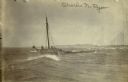
| Date: | 04 18 1897 |
|---|---|
| Description: | Schooner Charles N. Ryan wrecked in a storm north of Ludington, Michigan on April 18, 1897. Possibly a photograph of the crew being rescued by the L... |

| Date: | 10 01 1928 |
|---|---|
| Description: | One man is standing on an IH industrial tractor driver's seat while three other men are loading what appears to be a farm implement onto a trailer. The "In... |

| Date: | 1907 |
|---|---|
| Description: | A map of the eastern portion of the Apostle Islands group, and a detailed map of Gull Island showing the relief on the island, are included here, along wit... |

| Date: | 02 29 1912 |
|---|---|
| Description: | A man dressed in a suit and hat is standing next to a crane lifting machine crated for delivery. The wood building has tall ceilings and is filled with sta... |

| Date: | 1873 |
|---|---|
| Description: | Engraved image of a lock and dam at Sault St. Marie. Two men are operating the sluice as ships are waiting on the opposite side of the lock. Another man is... |

| Date: | 1872 |
|---|---|
| Description: | This 1872 map shows the proposed route of a canal between Sturgeon Bay, on the Green Bay side of the Door Peninsula, and Lake Michigan. Depths in both Stur... |

| Date: | 1952 |
|---|---|
| Description: | Map of the barley-growing regions of North America, published by the Rahr Malting Company, Manitowoc, Wisconsin, 1952. |

| Date: | 1990 |
|---|---|
| Description: | Map of bike routes in Madison. Lower right corner features a system map with legend. Upper left corner is an inset of the Capital Loop with labelled points... |

| Steamships, Canals and the 19th Century Economy |
|---|
| Discover what happened when 19th century Wisconsin settlers tried to construct a canal between the Mississippi and the Great Lakes. |

| Date: | 1890 |
|---|---|
| Description: | This map of Superior shows city wards, bays, docks, some businesses and points of interest. Relief is shown by hachures. The back of the map features a typ... |

| Date: | 1951 |
|---|---|
| Description: | This map of Superior shows labeled streets, waterways, railroads, and company ownership of docks. |

| Date: | 1932 |
|---|---|
| Description: | This map of Superior shows many points of interests including camping, fair grounds, docks, tourist attractions, lakes, roads, and waterways. |

| Date: | 1887 |
|---|---|
| Description: | This map shows lot and block numbers, established dock lines, docks, slips, railroads, and streets of West Superior in 1887. |

| Date: | 1889 |
|---|---|
| Description: | This map shows lot and block numbers, established dock lines, docks, slips, railroads, and streets of West Superior in 1889. |
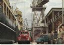
| Date: | 1950 |
|---|---|
| Description: | Color illustration of a shipyard scene with International trucks being loaded onto a ship at Station Pier in Melbourne, Victoria. Men are loading trucks an... |
If you didn't find the material you searched for, our Library Reference Staff can help.
Call our reference desk at 608-264-6535 or email us at: