 Filter: Subject of Quarries and quarrying

| Date: | 1862 |
|---|---|
| Description: | This map shows townships and sections, landownership and acreages, roads, railroads, cemeteries, churches, schools, mills, and stone quarries. "Engraved, p... |

| Date: | 1887 |
|---|---|
| Description: | This late 19th century map shows the lake region around Oconomowoc in Waukesha County and eastern Jefferson County, Wisconsin. Cities and villages, roads, ... |

| Date: | 1878 |
|---|---|
| Description: | This 1878 map of Wood County, Wisconsin, shows the township and range grid, towns, sections, cities, villages and post offices, landownership, roads, railr... |

| Date: | 1976 |
|---|---|
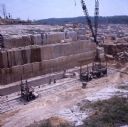
| Description: | Two workers and a large yellow crane at a limestone quarry. There are large blocks of roughly cut limestone, and numerous trees are in the background. The ... |
| Date: | 1976 |
|---|---|
| Description: | Color photo of workers cutting blocks of limestone in a quarry. There are what appear to be moveable platforms on tracks at the bottom of the face of the a... |

| Date: | 1836 |
|---|---|
| Description: | This map is pen-and-ink on paper and shows marshlands, rivers, creeks, a quarry, and a few roads. |
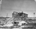
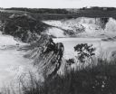
| Date: | 1924 |
|---|---|
| Description: | View from low section of quarry towards the processing plant up a steep rise. Tracks for hauling limestone are on the left near small sheds and a marshy ar... |

| Brief history of the quarrying industry in Wisconsin. |
| History of Sturgeon Bay, Wisconsin |
|---|
| Discover historical details and explore our online collections related to Sturgeon Bay, Wisconsin. |

| Date: | 1912 |
|---|---|
| Description: | Group portrait of quarrymen posing with their implements. There are carts on tracks that lead to the cliffs of the quarry behind the group. |

| Date: | |
|---|---|
| Description: | Photographic postcard view of a quarry with water at the bottom. Caption reads: "A Pit at the 'Klondike' Granite Quarry, Berlin, Wis." |
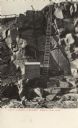
| Date: | 1904 |
|---|---|
| Description: | Photographic postcard view of the bottom of the quarry, with a ladder from the bottom of the pit to top. There is a shed at the foot of the ladder. Caption... |
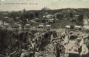
| Date: | |
|---|---|
| Description: | Partially colorized view looking down at a quarry. On the other side of the quarry is the town of Berlin, with dwellings and commercial buildings. Caption ... |
| Date: | 1963 |
|---|---|
| Description: | Sand and gravel pit used by the Dane County highway department as a source of supply. |

| Date: | 1902 |
|---|---|
| Description: | This map is watercolor and pen on paper and relief shown by contours. The map reads: "Contour interval 10 feet." Shown on the map are geological features a... |

| Date: | 07 1870 |
|---|---|
| Description: | This map of Ironton is pen-and-ink on paper and shows lots and block numbers, mill, foundry buildings, limestone quarry, iron mine, and roads. Relief is sh... |

| Date: | 1873 |
|---|---|
| Description: | This map shows landownership and acreages, lot and block numbers, roads and railroads, marshes, schools, churches, mills, rural buildings, and quarries. Re... |
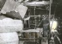
| Date: | 1910 |
|---|---|
| Description: | A workman poses beside a belt-driven polisher inside a shed at the Montello granite quarry. Two other men relax in the background near an open door where n... |
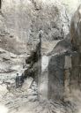
| Date: | 1910 |
|---|---|
| Description: | Two men stand on a ledge in the granite quarry in Montello. Three other men stand below. The side of the quarry rises up above the group in the background.... |
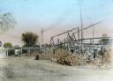
| Date: | 1910 |
|---|---|
| Description: | View of the Montello granite quarry grounds shows piles of granite paving blocks. In the background, a team of horses pulls a wagon under an elevated narro... |
If you didn't find the material you searched for, our Library Reference Staff can help.
Call our reference desk at 608-264-6535 or email us at: