 Filter: Subject of Quarries and quarrying
Filter: Subject of transportation
Filter: Subject of Quarries and quarrying
Filter: Subject of transportation
| Date: | |
|---|---|
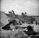
| Description: | A man is on a walkway on top of a mechanical conveyor belt machine that is loading sand and gravel into the bed of a truck. A steam shovel is visible in th... |
| Date: | 10 12 1938 |
|---|---|
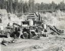
| Description: | Men work with a Universal crusher, used to crush 400 yards of gravel in 8 hours. The crusher was powered by an International PA-100 power unit owned by E.F... |
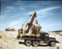
| Date: | 01 11 1938 |
|---|---|
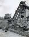
| Description: | Simmons stone crusher powered by an International power unit at a State Highway Commission stone quarry. |
| Date: | 12 22 1937 |
|---|---|
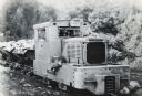
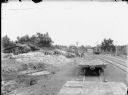
| Description: | Brookville locomotive pulling dump cars in a rock quarry owned by General Refractories Company. Two men can be seen sitting inside through the front window... |
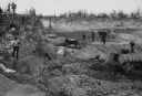
| Date: | 1888 |
|---|---|
| Description: | Men working in Horlick's stone quarry. Teams of horses pull wagons. There is a steam pump at right. A man in a hat and coat, possibly William Horlick, stan... |

| Date: | |
|---|---|
| Description: | Ladders extend into the quarry at Wisconsin Granite Company, and factory buildings and towers can be seen above. Three men stand near a railroad car at the... |
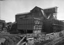
| Date: | |
|---|---|
| Description: | A man stands outside the rock crusher at the Wisconsin Granite Company quarry. To the right, railroad tracks span the side of the building. |
| Date: | 1952 |
|---|---|
| Description: | Color photograph of a model M-51 dump truck depositing raw lime rock from a quarry into the back of a truck marked "U.S. Air Force." Another vehicle is in ... |

| Date: | 1883 |
|---|---|
| Description: | Bird's-eye view of Montello, county seat of Marquette County. The granite quarry, woolen mill, and planing mill are clearly identified. A steamboat on Buf... |
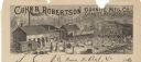
| Date: | |
|---|---|
| Description: | Letterhead of the Cohn & Robertson Granite Manufacturing Company of Granite Heights and Wausau, Wisconsin, with a view of workers loading a C.M.&St.P. rail... |
| Date: | |
|---|---|
| Description: | Group of men at the construction of a railroad branch line among piles of stones. Railroad ties placed on the ground are visible on the platform in the bac... |

| Date: | 1917 |
|---|---|
| Description: | A geological survey map that shows the sedimentary and igneous deposits in southeastern Wisconsin and south central Wisconsin, as well as the limits of gla... |
| Date: | |
|---|---|
| Description: | View down hill into quarry with men posed working the rock face behind a bobsled pulled by a team of two horses. A man is sitting in a cutter sleigh pulled... |

| Date: | 1905 |
|---|---|
| Description: | Stone quarry, with men working near a wagon, and at the base of the hill. In the background is a steep hill with trees. |

| Date: | 1915 |
|---|---|
| Description: | This map of Door County, Wisconsin, from the early 20th century shows roads, schools, churches, creameries and cheese factories, orchards, docks, quarries,... |

| Date: | 1889 |
|---|---|
| Description: | This 1889 map of Douglas County, Wisconsin, shows the township and range grid, towns, sections, cities and villages, roads, existing and proposed railroads... |

| Date: | 1892 |
|---|---|
| Description: | This 1892 map of Douglas County, Wisconsin, shows the township and range grid, towns, sections, cities and villages, roads, railroads, trails, lakes and st... |

| Date: | 1867 |
|---|---|
| Description: | This 1867 manuscript map by Increase Lapham shows the topography and geology of the Blue Mounds region in the Town of Brigham in Iowa County and the towns ... |
If you didn't find the material you searched for, our Library Reference Staff can help.
Call our reference desk at 608-264-6535 or email us at:

